IMAGES TAKEN NEAR TO
Hillview Crescent, MONTROSE, DD10 9RZ
Introduction
This page details the photographs taken nearby to Hillview Crescent, DD10 9RZ by members of the Geograph project.
The Geograph project started in 2005 with the aim of publishing, organising and preserving representative images for every square kilometre of Great Britain, Ireland and the Isle of Man.

There are currently over 7.5m images from over14,400 individuals and you can help contribute to the project by visiting https://www.geograph.org.uk
Image Map
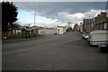
Images are licensed for reuse under creativecommons.org/licenses/by-sa/2.0
Notes
- Clicking on the map will re-center to the selected point.
- The higher the marker number, the further away the image location is from the centre of the postcode.
Image Listing (112 Images Found)
Images are licensed for reuse under creativecommons.org/licenses/by-sa/2.0
Image
Details
Distance
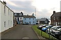
1
![South shore from north shore [4]](https://s0.geograph.org.uk/geophotos/05/02/86/5028668_94e74c09_120x120.jpg)
South shore from north shore [4]
Looking across the River South Esk from near the outer light.
Image: © Michael Dibb
Taken: 13 Jun 2016
0.02 miles
2
Rossie Square, Ferryden, Angus
Rossie Square is a central place in Ferryden and many passengers using the former ferry would have passed through here as they made their way to the nearby place of departure in order to cross the South Esk estuary to Montrose.
Image: © Adrian Diack
Taken: 24 Jul 2024
0.03 miles
3
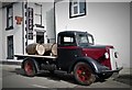
Diamond Lil's
Advertising lorry outside Diamond Lil's at Ferryden
Image: © Mary Rodgers
Taken: 15 Jul 2017
0.04 miles
5
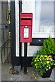
Elizabethan postbox on Brownlow Place, Ferryden
Outside the former Post Office.
Postbox No. DD10 32.
See Image] for context.
Image: © JThomas
Taken: 20 Jul 2021
0.04 miles
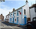
6
House on Brownlow Place, Ferryden
Showing position of Postbox No. DD10 32.
See Image] for postbox.
Image: © JThomas
Taken: 20 Jul 2021
0.04 miles
7
William Street, Ferryden at its junction with Rossie Square
Image: © Alan Morrison
Taken: 27 Dec 2008
0.05 miles
8
House at Ferryden
This is a house on the road to Scurdie Ness lighthouse. Note that the gable end is facing the water so that the windows are protected from the wind and spray. Just noticed the infilling above the door. Could this have been a house converted from some kind of industrial building? Could the centre window have been some kind of door with a hoist above? Comments welcome.
Image: © Dona Robbins
Taken: 17 Apr 2010
0.05 miles
9
The Old School in Usan Road, Ferryden
This is now a house.
Image: © Alan Morrison
Taken: 10 Mar 2009
0.06 miles
10
View of Brownlow Place, Ferryden
Picture taken from its junction with Usan Road, looking east.
Image: © Alan Morrison
Taken: 10 Mar 2009
0.06 miles