IMAGES TAKEN NEAR TO
Heron Bank, MONTROSE, DD10 9NG
Introduction
This page details the photographs taken nearby to Heron Bank, DD10 9NG by members of the Geograph project.
The Geograph project started in 2005 with the aim of publishing, organising and preserving representative images for every square kilometre of Great Britain, Ireland and the Isle of Man.

There are currently over 7.5m images from over14,400 individuals and you can help contribute to the project by visiting https://www.geograph.org.uk
Image Map
Images are licensed for reuse under creativecommons.org/licenses/by-sa/2.0
Notes
- Clicking on the map will re-center to the selected point.
- The higher the marker number, the further away the image location is from the centre of the postcode.
Image Listing (14 Images Found)
Images are licensed for reuse under creativecommons.org/licenses/by-sa/2.0
Image
Details
Distance
3
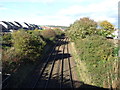
Railway heading north
East Coast Main Line towards Aberdeen.
Image: © JThomas
Taken: 23 Oct 2013
0.11 miles
4
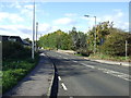
Railway towards Aberdeen
Looking north from the bridge on the A935.
Image: © JThomas
Taken: 11 Jun 2021
0.11 miles
5
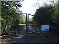
Entrance to Tayock
Scottish Wildlife Trust.
Image: © JThomas
Taken: 23 Oct 2013
0.13 miles
6
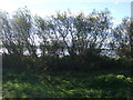
Trees, Tayock
Scottish Wildlife Trust on reclaimed land that was formerly a rubbish tip.
Image: © JThomas
Taken: 23 Oct 2013
0.14 miles
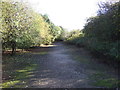
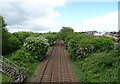
10
Tayock, Scottish Wildlife Trust
Reclaimed land that was formerly a rubbish tip.
Image: © JThomas
Taken: 23 Oct 2013
0.17 miles