IMAGES TAKEN NEAR TO
MONTROSE, DD10 9LP
Introduction
This page details the photographs taken nearby to DD10 9LP by members of the Geograph project.
The Geograph project started in 2005 with the aim of publishing, organising and preserving representative images for every square kilometre of Great Britain, Ireland and the Isle of Man.

There are currently over 7.5m images from over14,400 individuals and you can help contribute to the project by visiting https://www.geograph.org.uk
Image Map
Images are licensed for reuse under creativecommons.org/licenses/by-sa/2.0
Notes
- Clicking on the map will re-center to the selected point.
- The higher the marker number, the further away the image location is from the centre of the postcode.
Image Listing (7 Images Found)
Images are licensed for reuse under creativecommons.org/licenses/by-sa/2.0
Image
Details
Distance
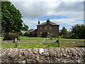
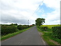
3
Muirton of Ballochy
A roadside farm just north of Dun.
Image: © Andrew Wood
Taken: 1 May 2010
0.19 miles
5
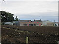
Ruined roof at Muirton of Ballochy
Collapsed roof on a farm building at Muirton of Ballochy.
Image: © Scott Cormie
Taken: 8 Sep 2018
0.20 miles
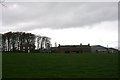
6
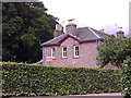
Muirton of Ballochy farmhouse
With farm name sign in the garden.
Image: © Stanley Howe
Taken: 24 Jul 2015
0.22 miles