IMAGES TAKEN NEAR TO
MONTROSE, DD10 9LJ
Introduction
This page details the photographs taken nearby to DD10 9LJ by members of the Geograph project.
The Geograph project started in 2005 with the aim of publishing, organising and preserving representative images for every square kilometre of Great Britain, Ireland and the Isle of Man.

There are currently over 7.5m images from over14,400 individuals and you can help contribute to the project by visiting https://www.geograph.org.uk
Image Map
Images are licensed for reuse under creativecommons.org/licenses/by-sa/2.0
Notes
- Clicking on the map will re-center to the selected point.
- The higher the marker number, the further away the image location is from the centre of the postcode.
Image Listing (5 Images Found)
Images are licensed for reuse under creativecommons.org/licenses/by-sa/2.0
Image
Details
Distance
1
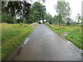
Road and Bridge crossing Pow Burn near Powmouth
Looking eastward.
Image: © Peter Wood
Taken: 10 Aug 2021
0.06 miles
2
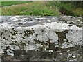
Ordnance Survey Cut Mark
This lichen covered mark can be found on the parapet wall of the road bridge crossing Pow Burn near to Powmouth.
The recorded details give a height of 8.2052 metres above sea level.
For more detail see : https://www.bench-marks.org.uk/bm162974
Image: © Peter Wood
Taken: 10 Aug 2021
0.06 miles
3
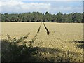
Track in the field
Deep tracks in a field of wheat near the Haughs of Kinnaird.
Image: © Scott Cormie
Taken: 19 Aug 2022
0.16 miles
4
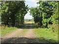
Former line of railway
Track marking the route of the former railway line between Friockheim and Hillside.
Image: © Scott Cormie
Taken: 19 Aug 2022
0.24 miles
5
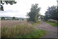
Caledonian trackbed
This was the railway from Perth to Aberdeen, a rival to the North British's coastal route. Now a farm track.
Image: © Richard Webb
Taken: 25 Aug 2018
0.24 miles