IMAGES TAKEN NEAR TO
The Woods, MONTROSE, DD10 9FY
Introduction
This page details the photographs taken nearby to The Woods, DD10 9FY by members of the Geograph project.
The Geograph project started in 2005 with the aim of publishing, organising and preserving representative images for every square kilometre of Great Britain, Ireland and the Isle of Man.

There are currently over 7.5m images from over14,400 individuals and you can help contribute to the project by visiting https://www.geograph.org.uk
Image Map
Images are licensed for reuse under creativecommons.org/licenses/by-sa/2.0
Notes
- Clicking on the map will re-center to the selected point.
- The higher the marker number, the further away the image location is from the centre of the postcode.
Image Listing (5 Images Found)
Images are licensed for reuse under creativecommons.org/licenses/by-sa/2.0
Image
Details
Distance
1

Ordnance Survey Flush Bracket G873
This bracket is on the parapet wall of a disused railway bridge near Hillside.
The recorded details give a height of 38.2674 metres above sea level.
For more detail see : https://www.bench-marks.org.uk/bm17763
Image: © Peter Wood
Taken: 8 Aug 2021
0.09 miles
2
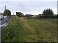
Track to Marykirk Road (A937) crossing the Dundee to Aberdeen railway line
Looking westward.
Image: © Peter Wood
Taken: 8 Aug 2021
0.10 miles
3
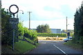
Rather Outdated Sign at Royal Sunnyside Hospital / Montrose / Marykirk Junction
Image: © Alan Morrison
Taken: 11 Oct 2008
0.10 miles
4
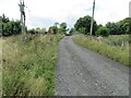
Lane heading over railway line
Off the A937 lane heading over railway line towards the River North Esk
Image: © Shaun Ferguson
Taken: 18 Aug 2011
0.11 miles
5
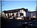
Wellfield cottage
Image: © Dominic Dawn Harry and Jacob Paterson
Taken: 17 Nov 2005
0.19 miles