IMAGES TAKEN NEAR TO
Macnab Avenue, MONTROSE, DD10 9FF
Introduction
This page details the photographs taken nearby to Macnab Avenue, DD10 9FF by members of the Geograph project.
The Geograph project started in 2005 with the aim of publishing, organising and preserving representative images for every square kilometre of Great Britain, Ireland and the Isle of Man.

There are currently over 7.5m images from over14,400 individuals and you can help contribute to the project by visiting https://www.geograph.org.uk
Image Map
Images are licensed for reuse under creativecommons.org/licenses/by-sa/2.0
Notes
- Clicking on the map will re-center to the selected point.
- The higher the marker number, the further away the image location is from the centre of the postcode.
Image Listing (20 Images Found)
Images are licensed for reuse under creativecommons.org/licenses/by-sa/2.0
Image
Details
Distance
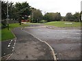
1
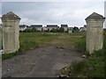
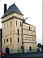
Macnab Avenue
Macnab Avenue now waiting redevelopment but previously Macnab distilleries ltd owners of the nearby also now demolished Lochside distillery
Image: © Shaun Ferguson
Taken: 1 Jun 2010
0.07 miles
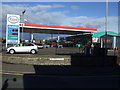
4
The Lochside Bar, Montrose
On North Esk Road.
Image: © JThomas
Taken: 11 Jun 2021
0.12 miles
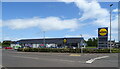
5
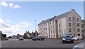
Brechin Road junction, Montrose
Traffic light controlled junction at South Esk Road (A92) on its northern approach into Montrose. The block of flats on the corner was the site of the former Lochside Distillery.
Image: © Stanley Howe
Taken: 24 Jul 2015
0.13 miles
6
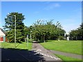
Broomfield Junction railway station (site), Montrose
Opened in 1865 by the Montrose & Bervie Railway, later part of the North British Railway, this diminutive halt is believed to have closed in 1877 (needs confirmation). The main reason for its existence was to avoid paying access charges to the Caledonian Railway station in Montrose (see Image).
View north towards Dubton (the course of the path) on the Caledonian's Forfar-Aberdeen line, and Bervie, curving away to the right. The single platform halt served the Bervie line only and was in the "V" of the junction, now in the trees. No trace exists.
Image: © Nigel Thompson
Taken: 8 Sep 2018
0.14 miles
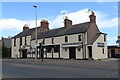
7
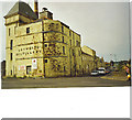
Montrose, Lochside Distillery
Derelict distillery is now demolished, houses are now built on this site (2008). View is taken looking west along the Brechin Road from the traffic lights junction on the main road north to Aberdeen.
Image: © Colin Smith
Taken: 31 Aug 2000
0.14 miles
9
NCN 1, Bloomfield Crescent
Route 1 of the National Cycle Network uses the trackbed of the Montrose Branch of the Caledonian Railway. Montrose used to be served by two stations. The current one belonged to the North British.
Image: © Richard Webb
Taken: 21 Sep 2009
0.15 miles
10

India Shed
Built in 1913 this is one of the three original hangars on Montrose airfield. Now part of an industrial estate they are still in use although not sadly housing aircraft.
Image: © Andrew Wood
Taken: 16 May 2015
0.15 miles