IMAGES TAKEN NEAR TO
Angus Drive, MONTROSE, DD10 9DZ
Introduction
This page details the photographs taken nearby to Angus Drive, DD10 9DZ by members of the Geograph project.
The Geograph project started in 2005 with the aim of publishing, organising and preserving representative images for every square kilometre of Great Britain, Ireland and the Isle of Man.

There are currently over 7.5m images from over14,400 individuals and you can help contribute to the project by visiting https://www.geograph.org.uk
Image Map
Images are licensed for reuse under creativecommons.org/licenses/by-sa/2.0
Notes
- Clicking on the map will re-center to the selected point.
- The higher the marker number, the further away the image location is from the centre of the postcode.
Image Listing (17 Images Found)
Images are licensed for reuse under creativecommons.org/licenses/by-sa/2.0
Image
Details
Distance
2
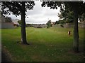
Aberdeen Railway: Montrose branch
Now grassed over and used as a park. The bridge is fenced off though.
Image: © Richard Webb
Taken: 21 Sep 2009
0.09 miles
4
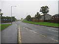
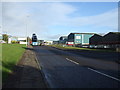
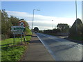
Coronation Avenue (A937)
Heading into Montrose.
Image: © JThomas
Taken: 11 Nov 2013
0.17 miles
5
Industrial estate road, Montrose
Off Coronation Avenue.
Image: © JThomas
Taken: 11 Nov 2013
0.17 miles
6
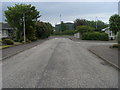
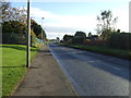
Ben More Avenue
Ben More Avenue leading to Coronation Avenue (A937)
Image: © Shaun Ferguson
Taken: 1 Jun 2010
0.17 miles
7
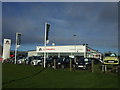
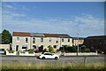
Car dealership, Montrose
Off Coronation Avenue.
Image: © JThomas
Taken: 11 Nov 2013
0.17 miles
10
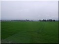
View across a field to Borrowfield Farm
From the railway north out of Montrose.
Image: © Stanley Howe
Taken: 27 Jun 2015
0.20 miles