IMAGES TAKEN NEAR TO
Coronation Way, MONTROSE, DD10 9DJ
Introduction
This page details the photographs taken nearby to Coronation Way, DD10 9DJ by members of the Geograph project.
The Geograph project started in 2005 with the aim of publishing, organising and preserving representative images for every square kilometre of Great Britain, Ireland and the Isle of Man.

There are currently over 7.5m images from over14,400 individuals and you can help contribute to the project by visiting https://www.geograph.org.uk
Image Map
Images are licensed for reuse under creativecommons.org/licenses/by-sa/2.0
Notes
- Clicking on the map will re-center to the selected point.
- The higher the marker number, the further away the image location is from the centre of the postcode.
Image Listing (9 Images Found)
Images are licensed for reuse under creativecommons.org/licenses/by-sa/2.0
Image
Details
Distance
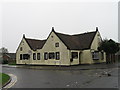
1
Montrose Baptist Church
Montrose Baptist Church viewed from Coronation Way in the Borrowfield district of Montrose.
Image: © Scott Cormie
Taken: 12 Jun 2021
0.04 miles
2
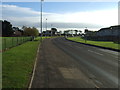
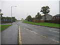
Coronation Avenue (A937)
Heading into Montrose.
Image: © JThomas
Taken: 11 Nov 2013
0.09 miles
4
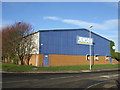
Builders merchants, Montrose
Off Forties Road.
Image: © JThomas
Taken: 11 Nov 2013
0.12 miles
6
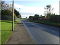
Coronation Avenue (A937)
Heading into Montrose.
Image: © JThomas
Taken: 11 Nov 2013
0.21 miles
7
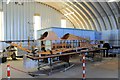
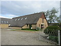
Replica being built
As part of the work in Montrose Air Museum a replica BE2 aircraft is being built. This was one of the types of aircraft that flew from Montrose in WW1.
Image: © Andrew Wood
Taken: 16 May 2015
0.23 miles
8
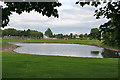
Pond at Borrowfield
The landscaping around the large housing estate incorporates this pond beside Newhame Road.
Image: © Anne Burgess
Taken: 27 Aug 2013
0.24 miles
9
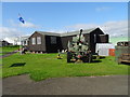
Montrose Air Station Heritage Centre
The Royal Flying Corps transferred from Upper Dysart Farm Imageto the airfield in January 1914.
Image: © John M
Taken: 2 Sep 2017
0.25 miles