IMAGES TAKEN NEAR TO
Rosehill Road, MONTROSE, DD10 8RY
Introduction
This page details the photographs taken nearby to Rosehill Road, DD10 8RY by members of the Geograph project.
The Geograph project started in 2005 with the aim of publishing, organising and preserving representative images for every square kilometre of Great Britain, Ireland and the Isle of Man.

There are currently over 7.5m images from over14,400 individuals and you can help contribute to the project by visiting https://www.geograph.org.uk
Image Map
Images are licensed for reuse under creativecommons.org/licenses/by-sa/2.0
Notes
- Clicking on the map will re-center to the selected point.
- The higher the marker number, the further away the image location is from the centre of the postcode.
Image Listing (38 Images Found)
Images are licensed for reuse under creativecommons.org/licenses/by-sa/2.0
Image
Details
Distance
1
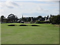
Montrose Golf Links, 1562 Course, 13th Hole, Gates
The thirteenth hole on the 1562 Course, looking to the green which lies close to the edge of the town.
Image: © Scott Cormie
Taken: 10 Oct 2019
0.07 miles
2
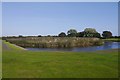
Square pond, Montrose Links
Strikingly regular when seen on a map. Marked on older maps as a skating pond.
Image: © Richard Webb
Taken: 23 Sep 2017
0.08 miles
3
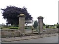
Cemetery Gates
Rosehill cemetery is on the road of the same name.
Image: © Michael Dibb
Taken: 17 Jun 2016
0.08 miles

6
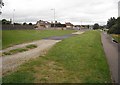
Rose Hill
The path is now used by National Cycle Route 1, but was originally a branch of the Aberdeen Railway serving Montrose. Closed along with the station in favour of the current station on a through route.
Image: © Richard Webb
Taken: 21 Sep 2009
0.11 miles
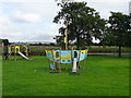
7
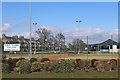
Montrose Tennis Club
Six courts. Pavilion refurbished in 2008.
Image: © Leslie Barrie
Taken: 6 Apr 2013
0.13 miles
8
Montrose Broomfield, 8th hole, Whinfield
The short eighth hole on the Broomfield Course at Montrose from tee to green, the floodlights of Montrose FC in the background.
Image: © Scott Cormie
Taken: 1 Apr 2017
0.17 miles
9
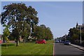
Warrack Terrace
One of a pair of parallel roads either side of Mid Links, a park. Obviously this part of town was built on links. Further on somebody objected to me being on the road. Poor thing was not going to wait three whole seconds before pulling out of a parking place.
Image: © Richard Webb
Taken: 23 Sep 2017
0.17 miles
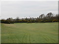
10
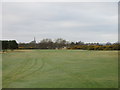
Montrose Broomfield, 7th hole, Lang Stracht
The seventh hole on the Broomfield Course at Montrose with the green in the distance and Montrose spire beyond.
Image: © Scott Cormie
Taken: 1 Apr 2017
0.18 miles