IMAGES TAKEN NEAR TO
John Street, MONTROSE, DD10 8LZ
Introduction
This page details the photographs taken nearby to John Street, DD10 8LZ by members of the Geograph project.
The Geograph project started in 2005 with the aim of publishing, organising and preserving representative images for every square kilometre of Great Britain, Ireland and the Isle of Man.

There are currently over 7.5m images from over14,400 individuals and you can help contribute to the project by visiting https://www.geograph.org.uk
Image Map
Images are licensed for reuse under creativecommons.org/licenses/by-sa/2.0
Notes
- Clicking on the map will re-center to the selected point.
- The higher the marker number, the further away the image location is from the centre of the postcode.
Image Listing (278 Images Found)
Images are licensed for reuse under creativecommons.org/licenses/by-sa/2.0
Image
Details
Distance
1
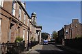
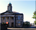
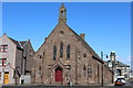
John Street, Montrose
The domed tower belongs to the former St John's United Free Church. There are many elegant buildings in this part of the town.
Image: © Richard Webb
Taken: 23 Sep 2017
0.01 miles
2
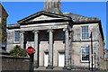
Former St John's United Free Church, Montrose
Architects William Smith 1829 and later John More Dick Peddie 1901
Image: © Leslie Barrie
Taken: 6 Apr 2013
0.03 miles
3
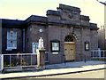
Parish Council Chambers at Montrose
Opened in 1915 at John Street.
Image: © Ann Harrison
Taken: 11 May 2009
0.03 miles
5
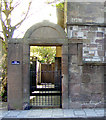
Former church at John Street
This imposing building is now for sale.
It was originally the Church of St Luke and St John and later the premises of Montrose Review Press.
http://canmore.rcahms.gov.uk/en/site/195671/details/montrose+59+john+street+st+john+s+united+free+church+and+hall/
Image: © Ann Harrison
Taken: 11 May 2009
0.04 miles
6
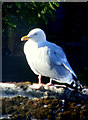
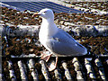
A Herring Gull
The only grey-backed gull that nests on roofs in seaside towns.
Image: © Ann Harrison
Taken: 11 May 2009
0.04 miles
8
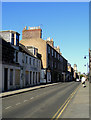
John Street at Montrose
Some of the dwellings in this street are boarded up, seemingly suffering from subsidence
Image: © Ann Harrison
Taken: 11 May 2009
0.04 miles
9
Methodist Church, Montrose
The former St John's United Free Church can be seen in the far distance
Image: © Leslie Barrie
Taken: 6 Apr 2013
0.05 miles
10
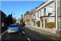
John Street, Montrose
The Park Hotel is on the right. In the distance is the portico and tower of the Category B listed former St Luke's and St John's Church [http://www.geograph.org.uk/photo/1310678].
Image: © Richard Sutcliffe
Taken: 28 Sep 2017
0.05 miles