IMAGES TAKEN NEAR TO
Palmerston Street, MONTROSE, DD10 8HR
Introduction
This page details the photographs taken nearby to Palmerston Street, DD10 8HR by members of the Geograph project.
The Geograph project started in 2005 with the aim of publishing, organising and preserving representative images for every square kilometre of Great Britain, Ireland and the Isle of Man.

There are currently over 7.5m images from over14,400 individuals and you can help contribute to the project by visiting https://www.geograph.org.uk
Image Map
Images are licensed for reuse under creativecommons.org/licenses/by-sa/2.0
Notes
- Clicking on the map will re-center to the selected point.
- The higher the marker number, the further away the image location is from the centre of the postcode.
Image Listing (201 Images Found)
Images are licensed for reuse under creativecommons.org/licenses/by-sa/2.0
Image
Details
Distance
1
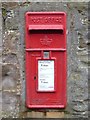
Letter box
The box is unusual in that it bears no royal cypher.
Image: © Michael Dibb
Taken: 13 Jun 2016
0.04 miles
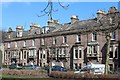
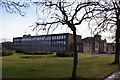
3
Montrose Academy
View from Academy Square. The Ordnance Survey have a problem with schools named X Academy, they label them as Academy on maps. In Scotland that makes as much sense as putting Rovers next to a football ground. It is an Angus Council maintained secondary school. There is no political or status meaning to the word "Academy" in Scotland.
Image: © Richard Webb
Taken: 22 Jul 2024
0.07 miles
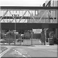
4
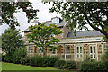
![Once were trains [1]](https://s1.geograph.org.uk/geophotos/05/02/85/5028589_fb331203_120x120.jpg)
Once were trains [1]
This delightful building was once the terminal station for the Aberdeen Railway (later the Caledonian Railway) branch line that led from the main Forfar to Aberdeen line at Dubton Junction and opened in 1849, closing in 1934. The building is listed, category B, and details are at: http://www.britishlistedbuildings.co.uk/sc-38220
Image: © Michael Dibb
Taken: 13 Jun 2016
0.07 miles
5
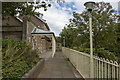
Former Caledonian Railway Station, Caledonian House, Railway Place, Montrose
The Montrose railway station for the Caledonian Railway was opened on the 1st February 1848 by the Aberdeen railway as a terminus for a short branch line from Dubton Junction. The station was closed to passengers on the 30th April 1934 and locos from Dubton subsequently ran to the North British railway station on the edge of Montrose Basin.
Image: © Andrew Diack
Taken: 22 Aug 2020
0.07 miles
6
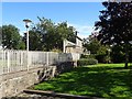
Former Caledonian Railway Station, Caledonian House, Montrose
This view of the former, railway station shows the platform and where the railway line ran.
Image: © Andrew Diack
Taken: 22 Aug 2020
0.07 miles
7
Former Caledonian Railway Station platform canopy
The original canopy was a wider structure which covered the platform and the track but this was replaced by the lighter cover shown in the photo.
Image: © Andrew Diack
Taken: 22 Aug 2020
0.07 miles
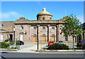
8
Montrose (Caledonian) railway station (site), Angus
Opened in 1849 by the Aberdeen Railway, later part of the Caledonian Railway, as the terminus of a short branch line from Dubton, this station closed to passengers in 1934 when services were transferred to the current Montrose station.
View north east along the sole platform. The original canopy covered both the platform and the track, but has been replaced by something a little lighter.
Image: © Nigel Thompson
Taken: 8 Sep 2018
0.07 miles
10
Montrose Academy
Taken from Panmure Terrace, Montrose.
Image: © Alan Morrison
Taken: 2 Feb 2008
0.07 miles