IMAGES TAKEN NEAR TO
Erskine Place, MONTROSE, DD10 8HJ
Introduction
This page details the photographs taken nearby to Erskine Place, DD10 8HJ by members of the Geograph project.
The Geograph project started in 2005 with the aim of publishing, organising and preserving representative images for every square kilometre of Great Britain, Ireland and the Isle of Man.

There are currently over 7.5m images from over14,400 individuals and you can help contribute to the project by visiting https://www.geograph.org.uk
Image Map
Images are licensed for reuse under creativecommons.org/licenses/by-sa/2.0
Notes
- Clicking on the map will re-center to the selected point.
- The higher the marker number, the further away the image location is from the centre of the postcode.
Image Listing (222 Images Found)
Images are licensed for reuse under creativecommons.org/licenses/by-sa/2.0
Image
Details
Distance
1
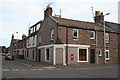
Railway Place and Ferry Street
The building in this corner has a curious little corbelled corner at first floor level, matched by one on Image] diagonally across the street.
Image: © Anne Burgess
Taken: 27 Aug 2013
0.01 miles
2
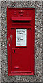
Post Box
This post box bears the legend 'E VII R' for 'Edwardus Rex' and dates from the reign of King Edward VII (1901-1910). He was not the seventh King Edward of Scots, the first six having been Kings of England before the Union of the Crowns in 1603. He was the first King Edward of the United Kingdom.
Image: © Anne Burgess
Taken: 27 Aug 2013
0.02 miles
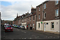
3
Junction of Ferry Street with Commerce Street, Montrose
Image: © Stanley Howe
Taken: 20 Aug 2013
0.02 miles
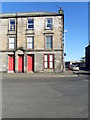
4
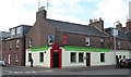
Caledonian Bar
The corner above the door, picked out in red, has a curious little corbel matching the one diagonally across the street at Image
Image: © Anne Burgess
Taken: 27 Aug 2013
0.02 miles
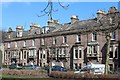
5
Ferry Street
19th century terraced housing. Pity about all the non-matching window frames.
Image: © Anne Burgess
Taken: 27 Aug 2013
0.04 miles
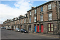
7
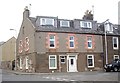
Ramsay Place
A typical early 19th century street.
Image: © Anne Burgess
Taken: 27 Aug 2013
0.06 miles
8
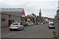
Ferry Street
A main street in the harbour area of Montrose, with the Steeple in the background.
Image: © Anne Burgess
Taken: 27 Aug 2013
0.06 miles
9

Bench Mark, Ferry Street
The bench mark is to be found on the junction of Ferry Street and Caledonia Street. For a wider view of the building Image and for further information on the cut mark http://www.bench-marks.org.uk/bm36143
Image: © Maigheach-gheal
Taken: 11 Oct 2010
0.07 miles
10
Housing, Montrose
The junction of Ferry Street and Caledonia Street. On the angle of the building is an Ordnance Survey bench mark.
Image: © Maigheach-gheal
Taken: 11 Oct 2010
0.07 miles