IMAGES TAKEN NEAR TO
St. Marys Road, DA9 9YN
Introduction
This page details the photographs taken nearby to St. Marys Road, DA9 9YN by members of the Geograph project.
The Geograph project started in 2005 with the aim of publishing, organising and preserving representative images for every square kilometre of Great Britain, Ireland and the Isle of Man.

There are currently over 7.5m images from over14,400 individuals and you can help contribute to the project by visiting https://www.geograph.org.uk
Image Map
Images are licensed for reuse under creativecommons.org/licenses/by-sa/2.0
Notes
- Clicking on the map will re-center to the selected point.
- The higher the marker number, the further away the image location is from the centre of the postcode.
Image Listing (98 Images Found)
Images are licensed for reuse under creativecommons.org/licenses/by-sa/2.0
Image
Details
Distance
1
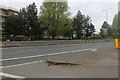
Crossways Boulevard, Stone
The buildings opposite are only a few months old, the area was previously parkland.
Image: © David Howard
Taken: 2 May 2022
0.02 miles
2
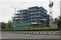
New flats under construction on Crossways Boulevard, Stone
This was parkland until this year.
Image: © David Howard
Taken: 2 May 2022
0.02 miles
3
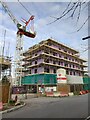
Construction of Braeburn Heights
This is one of two large blocks of housing being built on Barley Close.
Image: © David Anstiss
Taken: 9 Dec 2021
0.04 miles
4
CP Hart bathrooms on Crossways Boulevard, Stone
I remember dropping off parcels to them for work at their old place by Waterloo Station in the early 80s.
Image: © David Howard
Taken: 2 May 2022
0.06 miles
5
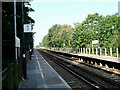
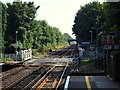
Platforms at Stone Crossing
Stone Crossing Station on the London bound platform looking towards Dartford
Image: © Glyn Baker
Taken: 4 Sep 2005
0.06 miles
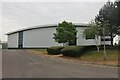
6
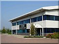
Hart Distribution (Stone)
This is one example of a whole estate of modern industrial units to the north of the A206 near Stone Crossing Station
Image: © Glyn Baker
Taken: 4 Sep 2005
0.06 miles
7
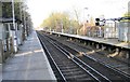
Stone Crossing railway station, Kent
Opened in 1849 by the South Eastern & Chatham Railway on the line from Dartford to Strood. View west towards Dartford.
Image: © Nigel Thompson
Taken: 20 Feb 2010
0.07 miles
8
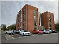
Housing on Barley Close
This block of flats is beside a road running parallel to the Gravesend to Dartford railway line (beyond the trees on the right).
Barley Close (on the left) is only used to access various block of housing (behind the viewer). The road leads forwards to Charles Street and then Crossways Boulevard (the A206).
Image: © David Anstiss
Taken: 9 Dec 2021
0.09 miles
10
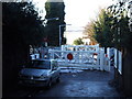
Stone Crossing Station - DA9
The level crossing at Stone Crossing Railway Station looking towards Greenhithe.
Image: © David Hallam-Jones
Taken: 5 Aug 2012
0.09 miles