IMAGES TAKEN NEAR TO
Parkwood Hill, GREENHITHE, DA9 9YD
Introduction
This page details the photographs taken nearby to Parkwood Hill, DA9 9YD by members of the Geograph project.
The Geograph project started in 2005 with the aim of publishing, organising and preserving representative images for every square kilometre of Great Britain, Ireland and the Isle of Man.

There are currently over 7.5m images from over14,400 individuals and you can help contribute to the project by visiting https://www.geograph.org.uk
Image Map
Images are licensed for reuse under creativecommons.org/licenses/by-sa/2.0
Notes
- Clicking on the map will re-center to the selected point.
- The higher the marker number, the further away the image location is from the centre of the postcode.
Image Listing (17 Images Found)
Images are licensed for reuse under creativecommons.org/licenses/by-sa/2.0
Image
Details
Distance
1
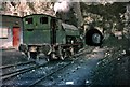
Steam locomotive at Swanscombe chalk quarries ? 1968
The quarries fed the Associated Portland Cement Manufacturers plant at Swanscombe, and the line included several tunnels below roads. The view gives some idea of the depth of the quarrying. The locomotive is No.7, built by Robert Stephenson and Hawthorns of Newcastle in 1948.
Image: © Alan Murray-Rust
Taken: 6 Jan 1968
0.08 miles
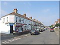
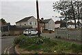
3
The Oasis on Knockhall Road, Greenhithe
It's not much of an oasis now.
Image: © David Howard
Taken: 2 May 2022
0.16 miles
7
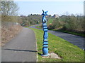
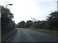
Millennium Milepost, Alkerden Lane, Swanscombe
There are four different types of Millennium Mileposts, commissioned by Sustrans. This one is known as The Cockerel and was designed by the Scottish sculptor Iain McColl. See http://www.sustrans.org.uk/what-we-do/national-cycle-network/mileposts for more information. The outskirts of Swanscombe are in the distance and Alkerden Farm lies down the hill to the right.
Image: © Marathon
Taken: 24 Mar 2012
0.18 miles
9
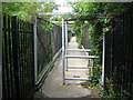
Footbridge over former Quarry Works
This bridge is on a footpath from Craylands Lane to Knockhall Road.
It crosses over a deep cutting which used to have a railway line running to a quarry works beside the A2. The cutting is now a Site of Special Scientific Interest.
Image: © David Anstiss
Taken: 22 Jul 2009
0.18 miles