
IMAGES TAKEN NEAR TO
Chalice Way, GREENHITHE, DA9 9PR
Introduction
This page details the photographs taken nearby to Chalice Way, DA9 9PR by members of the Geograph project.
The Geograph project started in 2005 with the aim of publishing, organising and preserving representative images for every square kilometre of Great Britain, Ireland and the Isle of Man.

There are currently over 7.5m images from over14,400 individuals and you can help contribute to the project by visiting https://www.geograph.org.uk
Image Map
Images are licensed for reuse under creativecommons.org/licenses/by-sa/2.0
Notes
- Clicking on the map will re-center to the selected point.
- The higher the marker number, the further away the image location is from the centre of the postcode.
Image Listing (127 Images Found)
Images are licensed for reuse under creativecommons.org/licenses/by-sa/2.0
Image
Details
Distance
1
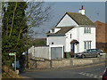
Corner house, Stone
At the corner of Church Road and Church Hill, with a good view out the back.
Image: © Robin Webster
Taken: 1 Mar 2012
0.06 miles
2
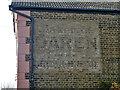
Wall advertisement, Upper Church Hill, Stone
'Maker of DAREN the best brown bread'. Once the rival of Hovis, but no more. It seems that the end house once had a bakery (it must have been small) and a licence for the bread.
Image: © Robin Webster
Taken: 1 Mar 2012
0.06 miles

5
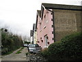
Stone: Upper Church Hill
Upper Church Hill is a short road off Church Hill with a few houses. However the end house does have an old painted brick advert which reads:
Maker of
DAREN
The Best
Brown Bread
suggesting that the house was formerly the village bakery. Daren was probably a trade name based on the old name for nearby Dartford (River Darent + ford).
Image: © Nigel Cox
Taken: 2 Mar 2008
0.07 miles
6
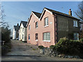
Upper Church Hill, Stone
A short close of just these houses.
Image: © Robin Webster
Taken: 1 Mar 2012
0.08 miles
7

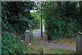
Church Hill near to Stone Crossing Station
Image: © Andrew Tatlow
Taken: 19 Jun 2015
0.08 miles
8

The church of St. Mary the Virgin, Stone
Looking at the west end from the entrance gate.
Image: © pam fray
Taken: 20 Jul 2009
0.08 miles
10
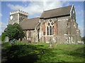
St Mary the Virgin Church, Stone
The description in Pevsner starts off by saying "The church is unforgettable, and its dingily dramatic surroundings are in their way equally so. The churchyard, on a promontory of the chalk cliffs above the Thames estuary, stands at the brink of a quarry, where two tremendous chimneys endlessly spew forth cement dust." Clearly all this has changed - the church has been cleaned and the churchyard is a nature reserve as indicated by the attractive notice board seen here alongside the path. The church dates from about 1260 and it is thought that the same masons who built Westminster Abbey also built Stone Church.
Image: © Marathon
Taken: 12 Apr 2011
0.08 miles