IMAGES TAKEN NEAR TO
Hillcrest Drive, GREENHITHE, DA9 9NH
Introduction
This page details the photographs taken nearby to Hillcrest Drive, DA9 9NH by members of the Geograph project.
The Geograph project started in 2005 with the aim of publishing, organising and preserving representative images for every square kilometre of Great Britain, Ireland and the Isle of Man.

There are currently over 7.5m images from over14,400 individuals and you can help contribute to the project by visiting https://www.geograph.org.uk
Image Map
Images are licensed for reuse under creativecommons.org/licenses/by-sa/2.0
Notes
- Clicking on the map will re-center to the selected point.
- The higher the marker number, the further away the image location is from the centre of the postcode.
Image Listing (73 Images Found)
Images are licensed for reuse under creativecommons.org/licenses/by-sa/2.0
Image
Details
Distance


8
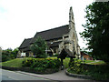
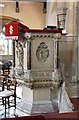
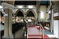
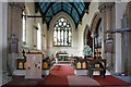
St Mary's Church, Greenhithe, Kent
Behind McDonald's Restaurant on the A226 to Gravesend is the quaint church of St Mary's. Facing east toward London it follows the direction alignment pattern of most ancient places of worship in England.
Image: © Ken Brown
Taken: 5 Aug 2008
0.03 miles
9
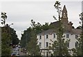
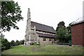
St Mary, Greenhithe, Kent from roundabout
Image: © John Salmon
Taken: 21 Jul 2009
0.03 miles