IMAGES TAKEN NEAR TO
Clovelly Place, GREENHITHE, DA9 9FB
Introduction
This page details the photographs taken nearby to Clovelly Place, DA9 9FB by members of the Geograph project.
The Geograph project started in 2005 with the aim of publishing, organising and preserving representative images for every square kilometre of Great Britain, Ireland and the Isle of Man.

There are currently over 7.5m images from over14,400 individuals and you can help contribute to the project by visiting https://www.geograph.org.uk
Image Map
Images are licensed for reuse under creativecommons.org/licenses/by-sa/2.0
Notes
- Clicking on the map will re-center to the selected point.
- The higher the marker number, the further away the image location is from the centre of the postcode.
Image Listing (38 Images Found)
Images are licensed for reuse under creativecommons.org/licenses/by-sa/2.0
Image
Details
Distance
1
Former Paper Mills Wharf
A jetty at this point was removed 2005-2006 as a new residential development replaced the industrial works here before.
Image: © Oast House Archive
Taken: 12 Aug 2011
0.04 miles
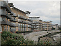
3
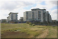
Housing in Wainwright Avenue, Ingress Park
Wainwright Avenue represents the eastern edge of Ingress Park, the extensive Crest Nicholson development centred around Ingress Abbey. Further construction work appears to be ongoing.
Image: © David Kemp
Taken: 5 Oct 2016
0.05 miles
4
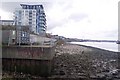
The end of the promenade near Ingress Park
This concrete wall leads past Ingress Park housing estate (built by Crest Nicholson) towards Greenhithe. Most of the Park is now completed. Image
Shows a former jetty on the site, now demolished due to the housing. Barges in the Thames still exist.
Image: © David Anstiss
Taken: 23 Oct 2009
0.07 miles
5
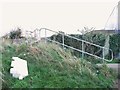
Steps near the site of Paper Mills Wharf
Image: © Chris Whippet
Taken: 16 Nov 2013
0.07 miles
6
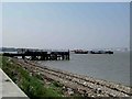
Jaded Jetty
The remains of an abandoned Jetty to the east of Greenhithe. It would have probably served the paper mill that was once nearby. The photograph was taken looking back towards Greenhithe. The QE2 bridge is in the background.
Image: © Glyn Baker
Taken: 4 Sep 2005
0.08 miles
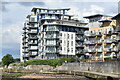
8
New apartments
Apartments on Portland Place, overlooking the River Thames.
Image: © Oast House Archive
Taken: 12 Aug 2011
0.08 miles
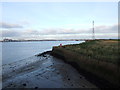
9
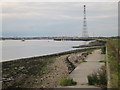
The riverside at Ingress Park
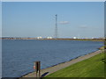
This is the view from the riverfront at Ingress Park near Greenhithe. Swanscombe Pylon dominates the scene, which at 623 feet is, along with its twin across the Thames at West Thurrock, the highest in the UK and the second highest in Europe. See http://www.geograph.org.uk/photo/1669490 for the view from beneath. The tower blocks beyond are at Grays in Essex.
Image: © Marathon
Taken: 24 Mar 2019
0.08 miles
10
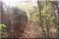
Footpath on Lover's Lane
This path leads from the A226 London Road towards the River Thames. The fence on the left is the boundary fence of Ingress Park construction site.
Image: © David Anstiss
Taken: 23 Oct 2009
0.11 miles