IMAGES TAKEN NEAR TO
High Street, DARTFORD, DA4 0DG
Introduction
This page details the photographs taken nearby to High Street, DA4 0DG by members of the Geograph project.
The Geograph project started in 2005 with the aim of publishing, organising and preserving representative images for every square kilometre of Great Britain, Ireland and the Isle of Man.

There are currently over 7.5m images from over14,400 individuals and you can help contribute to the project by visiting https://www.geograph.org.uk
Image Map (160 Images)


Leaflet Map data © OpenStreetMap
Images are licensed for reuse under creativecommons.org/licenses/by-sa/2.0
Notes
- Clicking on the map will re-center to the selected point.
- The higher the marker number, the further away the image location is from the centre of the postcode.
Image Listing (160 Images Found)
Images are licensed for reuse under creativecommons.org/licenses/by-sa/2.0
Image
Details
Distance
1

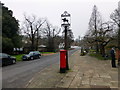
Market Meadow, Farningham
Apparently named for the monthly market and yearly Fair held here in the last century, it was donated to the village in 1997
Image: © PAUL FARMER
Taken: 9 Mar 2013
0.02 miles


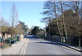
5

Farningham Bridge
Grade II listed. https://historicengland.org.uk/listing/the-list/list-entry/1222229
Image: © N Chadwick
Taken: 20 Aug 2019
0.02 miles
6

Farningham Bridge
Grade II listed. http://www.britishlistedbuildings.co.uk/en-414349-farningham-bridge-farningham-kent
Image: © N Chadwick
Taken: 2 Apr 2013
0.02 miles
8

The Mill, Farningham
Farningham with its old mill and bridge over the River Darent, as well as a wealth of old buildings, is one of the most attractive villages in Kent. It lay on the line on one of the two major routes between London and Dover, since by-passed by the A20, and that in its turn by the M20. This is the approach to the 18th century mill on the River Darent.
Image: © Marathon
Taken: 4 Oct 2012
0.03 miles

10

Cattle screen across the Darent, Farningham
This structure was at one time thought to be a folly or the remains of the north side of a medieval bridge, but is now considered in all probability to be a cattle screen. This would have been built to prevent cattle from wandering downstream when crossing the ford located where the bridge is now. It is thought to have been built between 1740 and 1770, and is the only one in the country to have been constructed in such an ornate manner. This was possibly because the owner of Farningham Manor wanted travellers through Farningham to appreciate how wealthy he was. On the left is the Lion Hotel.
Image: © Marathon
Taken: 2 Oct 2012
0.03 miles