IMAGES TAKEN NEAR TO
Hurlfield, DARTFORD, DA2 7BH
Introduction
This page details the photographs taken nearby to Hurlfield, DA2 7BH by members of the Geograph project.
The Geograph project started in 2005 with the aim of publishing, organising and preserving representative images for every square kilometre of Great Britain, Ireland and the Isle of Man.

There are currently over 7.5m images from over14,400 individuals and you can help contribute to the project by visiting https://www.geograph.org.uk
Image Map
Images are licensed for reuse under creativecommons.org/licenses/by-sa/2.0
Notes
- Clicking on the map will re-center to the selected point.
- The higher the marker number, the further away the image location is from the centre of the postcode.
Image Listing (19 Images Found)
Images are licensed for reuse under creativecommons.org/licenses/by-sa/2.0
Image
Details
Distance

7
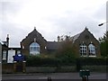
Barn End Centre, Wilmington
On Barn End Road.
Base of North West Kent Behaviour Service.
This was a former school building.
Image: © David Anstiss
Taken: 30 Oct 2012
0.12 miles
8
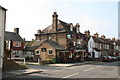
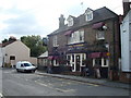
The Plough, Wilmington, Kent
This inviting local has the advantage of being the only pub in the village.
Image: © Dr Neil Clifton
Taken: 17 Sep 2006
0.14 miles
10
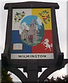
Wilmington Village Sign
As seen in Image
Shows Image, surrounded by Hops, cherries, Invicta (the prancing horse) and a book.
On the post is a small metal plaque "Kent Village of the Year 2003. Winner Older People, Large Village Section"
Image: © David Anstiss
Taken: 30 Oct 2012
0.16 miles