IMAGES TAKEN NEAR TO
London Road, DARTFORD, DA2 6BL
Introduction
This page details the photographs taken nearby to London Road, DA2 6BL by members of the Geograph project.
The Geograph project started in 2005 with the aim of publishing, organising and preserving representative images for every square kilometre of Great Britain, Ireland and the Isle of Man.

There are currently over 7.5m images from over14,400 individuals and you can help contribute to the project by visiting https://www.geograph.org.uk
Image Map
Images are licensed for reuse under creativecommons.org/licenses/by-sa/2.0
Notes
- Clicking on the map will re-center to the selected point.
- The higher the marker number, the further away the image location is from the centre of the postcode.
Image Listing (20 Images Found)
Images are licensed for reuse under creativecommons.org/licenses/by-sa/2.0
Image
Details
Distance
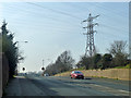
2
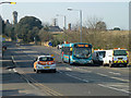
480 bus on London Road (A226)
A route from Dartford to the southern suburbs of Gravesend.
Image: © Robin Webster
Taken: 1 Mar 2012
0.04 miles
3
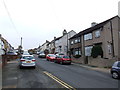
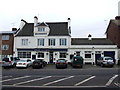
The Welsh Tavern Pub, Stone
On A226 London Road. Near Hill House road.
Image: © David Anstiss
Taken: 15 Feb 2009
0.05 miles
7
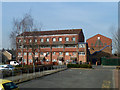
Flats, Alamein Gardens
The upper parts of these blocks are tile hung, with red and grey tiles. The long faces seem reasonably secure, but all the gable ends are a bit of a disaster, with a great many fallen and displaced tiles.
Image: © Robin Webster
Taken: 1 Mar 2012
0.07 miles
9
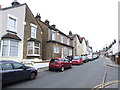
A226 London Road
Towards Dartford, as well as London.
Image: © Robin Webster
Taken: 1 Mar 2012
0.09 miles