IMAGES TAKEN NEAR TO
Stones Avenue, DARTFORD, DA1 5GU
Introduction
This page details the photographs taken nearby to Stones Avenue, DA1 5GU by members of the Geograph project.
The Geograph project started in 2005 with the aim of publishing, organising and preserving representative images for every square kilometre of Great Britain, Ireland and the Isle of Man.

There are currently over 7.5m images from over14,400 individuals and you can help contribute to the project by visiting https://www.geograph.org.uk
Image Map
Images are licensed for reuse under creativecommons.org/licenses/by-sa/2.0
Notes
- Clicking on the map will re-center to the selected point.
- The higher the marker number, the further away the image location is from the centre of the postcode.
Image Listing (37 Images Found)
Images are licensed for reuse under creativecommons.org/licenses/by-sa/2.0
Image
Details
Distance
3
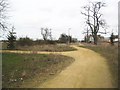
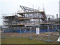
Dartford: Former Joyce Green Hospital site
This somewhat eerie place is the site of the former Joyce Green Hospital. It was built between 1901 and 1903 by the Metropolitan Asylums Board as a smallpox isolation hospital to replace the ships previously used for that purpose moored in the River Thames nearby. It was later used for the hospitalization of patients with other infectious diseases such as diphtheria, scarlet fever, measles and whooping-cough. It ultimately became a general hospital as part of the NHS before finally closing and being demolished in 2000. It had a tramway that used to convey patients from the jetties on the River Thames to the hospital and this may be the route of that tramway. All scales of the Ordnance Survey mapping currently show the former hospital layout but there is little left on the ground that can be identified on the maps, apart from the distant pylon, so I may be wrong with that assumption. The building work going on to the right is part of the new Bridge redevelopment of the site.
Image: © Nigel Cox
Taken: 2 Mar 2008
0.03 miles
9
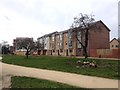
New School construction in The Bridge
Part of a new development on the former site of Joyce Green Hospital. Part of The Bridge. The building being built at the moment is a new 'Learning and Community Campus' (primary school plus....). Littlebrook Power Station chimney in background.
Image: © David Anstiss
Taken: 15 Feb 2009
0.07 miles
10
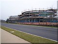
New School construction on empty bus route
Part of a new development on the former site of Joyce Green Hospital. Part of The Bridge. The building being built at the moment is a new 'Learning and Community Campus' (primary school plus....). Beside the new fasttrack bus route, linking the site with Dartford and Greenhithe.
Image: © David Anstiss
Taken: 15 Feb 2009
0.08 miles