IMAGES TAKEN NEAR TO
Hook Green Road, GRAVESEND, DA13 9ND
Introduction
This page details the photographs taken nearby to Hook Green Road, DA13 9ND by members of the Geograph project.
The Geograph project started in 2005 with the aim of publishing, organising and preserving representative images for every square kilometre of Great Britain, Ireland and the Isle of Man.

There are currently over 7.5m images from over14,400 individuals and you can help contribute to the project by visiting https://www.geograph.org.uk
Image Map
Images are licensed for reuse under creativecommons.org/licenses/by-sa/2.0
Notes
- Clicking on the map will re-center to the selected point.
- The higher the marker number, the further away the image location is from the centre of the postcode.
Image Listing (6 Images Found)
Images are licensed for reuse under creativecommons.org/licenses/by-sa/2.0
Image
Details
Distance
1

Hook Green
Looking south west along the road in Hook Green from beside Hook Green Farmhouse.
Image: © Trevor Harris
Taken: 10 Aug 2010
0.04 miles
2
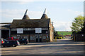
Oast House at Hook Place Farm, Hook Green Road, Southfleet, Kent
Image: © Oast House Archive
Taken: 22 Apr 2009
0.08 miles
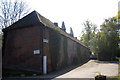
3

Hook Place Farm Oast
On access road within farm, off Hook Green Road.
Image: © David Anstiss
Taken: 30 Jan 2009
0.09 miles
4
Oast House at Hook Green Farmhouse, Hook Green Road, Southfleet, Kent
Image: © Oast House Archive
Taken: 22 Apr 2009
0.11 miles
5
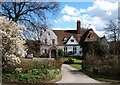
Friary Court; Southfleet
A former Monastic Grange
Image: © Glyn Baker
Taken: 1 Apr 2006
0.17 miles
6

Market garden harvesting, Southfleet
A squad of dark-skinned folk are harvesting some vegetable or other. Judging by the motley collection of crates and boxes, it is unlikely this is for the high end market.
Image: © Robin Webster
Taken: 25 Sep 2011
0.24 miles