IMAGES TAKEN NEAR TO
Manor Court, GRAVESEND, DA13 9BU
Introduction
This page details the photographs taken nearby to Manor Court, DA13 9BU by members of the Geograph project.
The Geograph project started in 2005 with the aim of publishing, organising and preserving representative images for every square kilometre of Great Britain, Ireland and the Isle of Man.

There are currently over 7.5m images from over14,400 individuals and you can help contribute to the project by visiting https://www.geograph.org.uk
Image Map
Images are licensed for reuse under creativecommons.org/licenses/by-sa/2.0
Notes
- Clicking on the map will re-center to the selected point.
- The higher the marker number, the further away the image location is from the centre of the postcode.
Image Listing (58 Images Found)
Images are licensed for reuse under creativecommons.org/licenses/by-sa/2.0
Image
Details
Distance
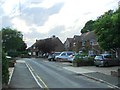
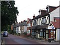
2
Sole Street
A fine display of daffodils brighten up the main road through Sole Street village.
Image: © Stephen McKay
Taken: 27 Mar 2017
0.08 miles
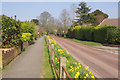
4
Spring at Sole Street
Daffodils and blossom brighten up the end of Scratton Fields, especially in the pleasant sunshine of a late March day.
Image: © Stephen McKay
Taken: 27 Mar 2017
0.08 miles
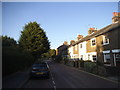
10
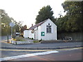
Tin church on Sole Street
This was St Mary's Church and is now the village hall
Image: © David Howard
Taken: 6 Sep 2015
0.11 miles