IMAGES TAKEN NEAR TO
The Coach Drive, GRAVESEND, DA13 0SZ
Introduction
This page details the photographs taken nearby to The Coach Drive, DA13 0SZ by members of the Geograph project.
The Geograph project started in 2005 with the aim of publishing, organising and preserving representative images for every square kilometre of Great Britain, Ireland and the Isle of Man.

There are currently over 7.5m images from over14,400 individuals and you can help contribute to the project by visiting https://www.geograph.org.uk
Image Map
Images are licensed for reuse under creativecommons.org/licenses/by-sa/2.0
Notes
- Clicking on the map will re-center to the selected point.
- The higher the marker number, the further away the image location is from the centre of the postcode.
Image Listing (75 Images Found)
Images are licensed for reuse under creativecommons.org/licenses/by-sa/2.0
Image
Details
Distance
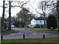
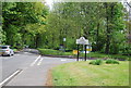
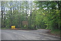
7
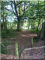
In Trosley Country Park
In the 1870s, Sir Sidney Waterlow purchased large areas of land including the Village of Fairseat, a good proportion of Stansted together with land from Wrotham to Meopham. In 1887 he built Trosley Towers on the crest of the escarpment to the east of Vigo Hill. It was approached by two drives and was surrounded by wooded grounds. Trosley Towers was demolished in 1936. The part of the estate to the east of Vigo Hill forms Trosley Country Park and part is now Vigo Village. For the history of the latter see the http://en.wikipedia.org/wiki/Vigo,_Kent The Country Park covers 170 acres of woodland and chalk downland - more detail can be found at http://www.kentdowns.org.uk/40-places/trosley-country-park
Image: © Marathon
Taken: 13 Sep 2011
0.06 miles
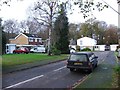
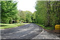
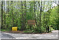
8
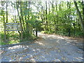
Entrance to Trosley Country Park
In the 1870s, Sir Sidney Waterlow purchased large areas of land including the Village of Fairseat, a good proportion of Stansted together with land from Wrotham to Meopham. In 1887 he built Trosley Towers on the crest of the escarpment to the east of Vigo Hill. It was approached by two drives and was surrounded by wooded grounds. Trosley Towers was demolished in 1936. The part of the estate to the east of Vigo Hill forms Trosley Country Park and part is now Vigo Village. For the history of the latter see https://en.wikipedia.org/wiki/Vigo,_Kent The Country Park covers 170 acres of woodland and chalk downland - more detail can be found at http://www.kent.gov.uk/leisure_and_culture/countryside_and_coast/parks_and_open_spaces/country_parks/trosley_country_park.aspx This is the main entrance in Waterlow Road, Vigo.
Image: © Marathon
Taken: 13 Sep 2011
0.06 miles