IMAGES TAKEN NEAR TO
Meopham Green, GRAVESEND, DA13 0QF
Introduction
This page details the photographs taken nearby to Meopham Green, DA13 0QF by members of the Geograph project.
The Geograph project started in 2005 with the aim of publishing, organising and preserving representative images for every square kilometre of Great Britain, Ireland and the Isle of Man.

There are currently over 7.5m images from over14,400 individuals and you can help contribute to the project by visiting https://www.geograph.org.uk
Image Map
Images are licensed for reuse under creativecommons.org/licenses/by-sa/2.0
Notes
- Clicking on the map will re-center to the selected point.
- The higher the marker number, the further away the image location is from the centre of the postcode.
Image Listing (90 Images Found)
Images are licensed for reuse under creativecommons.org/licenses/by-sa/2.0
Image
Details
Distance
1
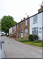
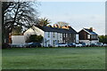
Meopham: Wellington Cottages, Pitfield Green
Named, no doubt, after the Duke of Wellington - so they could well date from before 1840.
Image: © Stefan Czapski
Taken: 11 May 2018
0.01 miles
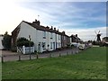
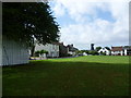
4
Meopham Green
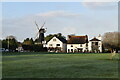
Meopham is said to have one of the longest village streets in Kent, at seven miles in length, but anyone who has gone from one end to the other must feel it is one of the longest in England. The main village is divided into four named settlements, and Meopham Green has by far the largest remaining village green in the parish. The main A227 road passes on the far side, and around the other two sides are buildings, many of which are of 18th and 19th century origin. Cricket has been played on Meopham Green since at least 1776. In the distance is Killick's Mill, built by James Killick, a millwright from Strood, in 1801. The mill worked by wind until 1929 and then by engine until 1965. It has been fully restored and is now in full working order.
Image: © Marathon
Taken: 12 Sep 2011
0.01 miles
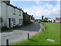
5

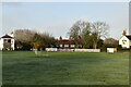
Meopham Green
A tranquil summers afternoon with a match in progress.
I had the pleasure of playing on this green many years ago.
History has it that cricket has been played on the green since 1776.
The Cricketers Inn pub, once known as the Long Hop, is just across the road. At one time I paid my annual allotment tithe in the parish office beneath the windmill.
The windmill, a Grade II listed building, was built by James Killick, a millwright from Strood, in 1801 and is still in working order.
From a scanned negative.
Image: © Richard Hoare
Taken: Unknown
0.02 miles
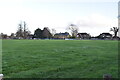
7
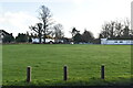
Meopham Green
Meopham is said to have one of the longest village streets in Kent, at seven miles in length, but anyone who has gone from one end to the other must feel it is one of the longest in England. The main village is divided into four named settlements, and Meopham Green has by far the largest remaining village green in the parish. The main A227 road passes on the far side, and around the other two sides are buildings, many of which are of 18th and 19th century origin. Cricket has been played on Meopham Green since at least 1776. In the distance is Killick's Mill, built by James Killick, a millwright from Strood, in 1801. The mill worked by wind until 1929 and then by engine until 1965. It has been fully restored and is now in full working order.
Image: © Marathon
Taken: 12 Sep 2011
0.02 miles