IMAGES TAKEN NEAR TO
Edmund Close, GRAVESEND, DA13 0NB
Introduction
This page details the photographs taken nearby to Edmund Close, DA13 0NB by members of the Geograph project.
The Geograph project started in 2005 with the aim of publishing, organising and preserving representative images for every square kilometre of Great Britain, Ireland and the Isle of Man.

There are currently over 7.5m images from over14,400 individuals and you can help contribute to the project by visiting https://www.geograph.org.uk
Image Map
Images are licensed for reuse under creativecommons.org/licenses/by-sa/2.0
Notes
- Clicking on the map will re-center to the selected point.
- The higher the marker number, the further away the image location is from the centre of the postcode.
Image Listing (48 Images Found)
Images are licensed for reuse under creativecommons.org/licenses/by-sa/2.0
Image
Details
Distance
2
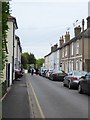
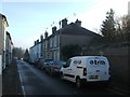
Meopham: Station Road
Perhaps originally constructed to accommodate railway workers - now very handy for commuters.
Image: © Stefan Czapski
Taken: 11 May 2018
0.06 miles

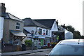
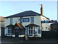
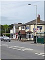
5
The Railway Tavern, Meopham
On Wrotham Road.
See Image] for sign.
Image: © JThomas
Taken: 21 Jun 2022
0.08 miles
7
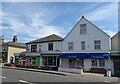
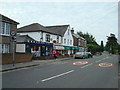
Post Office and shops on Wrotham Road, Meopham
Showing position of Postbox No. DA13 95.
See Image] for postbox.
Image: © JThomas
Taken: 21 Jun 2022
0.08 miles
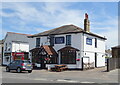
10
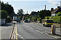
Meopham: the Railway Tavern and station approach
Close to the station, and a mile or two north of the old village centre. Photo taken across the A227 Gravesend-Wrotham road.
Image: © Stefan Czapski
Taken: 11 May 2018
0.08 miles