IMAGES TAKEN NEAR TO
Johns Road, GRAVESEND, DA13 0LP
Introduction
This page details the photographs taken nearby to Johns Road, DA13 0LP by members of the Geograph project.
The Geograph project started in 2005 with the aim of publishing, organising and preserving representative images for every square kilometre of Great Britain, Ireland and the Isle of Man.

There are currently over 7.5m images from over14,400 individuals and you can help contribute to the project by visiting https://www.geograph.org.uk
Image Map
Images are licensed for reuse under creativecommons.org/licenses/by-sa/2.0
Notes
- Clicking on the map will re-center to the selected point.
- The higher the marker number, the further away the image location is from the centre of the postcode.
Image Listing (39 Images Found)
Images are licensed for reuse under creativecommons.org/licenses/by-sa/2.0
Image
Details
Distance
1
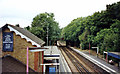
Meopham, westward 2002
View west, towards Swanley, Bromley and London (Victoria and Holborn Viaduct), ex-SE&CR London - Ramsgate/Dover via Chatham main line.
Image: © Ben Brooksbank
Taken: 15 Sep 2002
0.07 miles
2

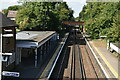
Meopham station, eastward 1989
View east, towards Chatham, Faversham, Ramsgate/Dover on the ex-SE&CR main line, electrified London - Gillingham 1939, Ramsgate/Dover 1958
Image: © Ben Brooksbank
Taken: 4 Jun 1989
0.07 miles
3

Orchard Drive, Meopham
Bungalows on a small housing estate close to the station. John's Road leads off to the right.
Image: © Stephen McKay
Taken: 27 Mar 2017
0.08 miles


7

Sign for the Railway Tavern, Meopham
See Image] for context.
Image: © JThomas
Taken: 21 Jun 2022
0.13 miles
8
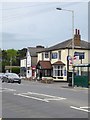
Meopham: the Railway Tavern and station approach
Close to the station, and a mile or two north of the old village centre. Photo taken across the A227 Gravesend-Wrotham road.
Image: © Stefan Czapski
Taken: 11 May 2018
0.13 miles
9

The Railway Tavern, Meopham
This pub dates from 1861 which was the same year that the adjacent railway station opened. It served as a hotel until 1905 and was at one time a Courage house.
Image: © Stephen McKay
Taken: 27 Mar 2017
0.13 miles
10
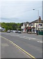
Meopham: the Railway Tavern and station approach
The village straggles for a couple of miles along the A227 Gravesend-Wrotham road. The station is at the northernmost end of the village, more than a mile north of the medieval parish church. The village green - which seems to represent the ancient village centre - lies yet further south.
The South Eastern Railway arrived in 1861, and named the station 'Meopham' even though it had 'missed' the village by a mile or two. Not that that matters nowadays, as a century and a half of development has largely filled the gap.
In the picture, the current station building - low and white-painted - can be glimpsed between the nearer buildings. Of the original station buildings not much remains.
Image: © Stefan Czapski
Taken: 11 May 2018
0.13 miles