IMAGES TAKEN NEAR TO
Evenden Road, GRAVESEND, DA13 0HG
Introduction
This page details the photographs taken nearby to Evenden Road, DA13 0HG by members of the Geograph project.
The Geograph project started in 2005 with the aim of publishing, organising and preserving representative images for every square kilometre of Great Britain, Ireland and the Isle of Man.

There are currently over 7.5m images from over14,400 individuals and you can help contribute to the project by visiting https://www.geograph.org.uk
Image Map
Images are licensed for reuse under creativecommons.org/licenses/by-sa/2.0
Notes
- Clicking on the map will re-center to the selected point.
- The higher the marker number, the further away the image location is from the centre of the postcode.
Image Listing (32 Images Found)
Images are licensed for reuse under creativecommons.org/licenses/by-sa/2.0
Image
Details
Distance
1
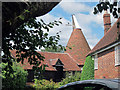
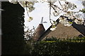
Evenden Oast House, Wrotham Road, Meopham
Image: © Oast House Archive
Taken: 24 Jul 2011
0.14 miles
2
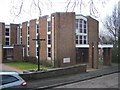
St Paul's Catholic Church, Hook Green
On junction of Huntingfield Road (unseen to left) and Wrotham Road (in front). Has engraved stone near doorway which reads 'This foundation stone was laid by the right reverend Cyril C.Cowderoy Bishop of Southwark 15th Aug 1964'.
Image: © David Anstiss
Taken: 30 Jan 2009
0.14 miles
7
Evenden Oast House, Wrotham Road, Meopham, Kent
Image: © Oast House Archive
Taken: 26 Apr 2008
0.17 miles