IMAGES TAKEN NEAR TO
Walnut Tree Way, GRAVESEND, DA13 0EH
Introduction
This page details the photographs taken nearby to Walnut Tree Way, DA13 0EH by members of the Geograph project.
The Geograph project started in 2005 with the aim of publishing, organising and preserving representative images for every square kilometre of Great Britain, Ireland and the Isle of Man.

There are currently over 7.5m images from over14,400 individuals and you can help contribute to the project by visiting https://www.geograph.org.uk
Image Map
Images are licensed for reuse under creativecommons.org/licenses/by-sa/2.0
Notes
- Clicking on the map will re-center to the selected point.
- The higher the marker number, the further away the image location is from the centre of the postcode.
Image Listing (22 Images Found)
Images are licensed for reuse under creativecommons.org/licenses/by-sa/2.0
Image
Details
Distance
1

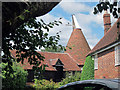
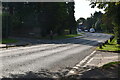
Evenden Oast House, Wrotham Road, Meopham, Kent
Image: © Oast House Archive
Taken: 26 Apr 2008
0.10 miles
2
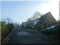
Evenden Oast House, Wrotham Road, Meopham
Image: © Oast House Archive
Taken: 24 Jul 2011
0.13 miles
3
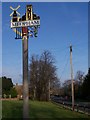
Meopham Village Sign
On small triangular green where Melliker Lane meets Wrotham Road (seen in photo on right). Had small metal plaque with engraved inscription 'This sign was donated to the village by Meopham Historical Society to commemorate it's 25th Anniversary in July 1998. Designed by Eric J. Bugg - A local resident, Fabricated by Jonathan Marchant - Blacksmith, Gilded and painted by Terry Morris - Signwriter and Erected by Tony Costin - Builder.'
Image: © David Anstiss
Taken: 30 Jan 2009
0.17 miles
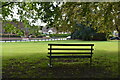
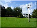
6
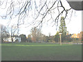
Hook Green
A modest village green; the village of Hook Green is now part of Meopham.
Image: © Stephen Craven
Taken: 14 Jan 2007
0.18 miles
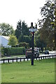
9
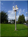
Meopham Village sign
Meopham is said to have one of the longest village streets in Kent, at seven miles in length, but anyone who has gone from one end to the other must feel it is one of the longest in England. The main village is divided into four named settlements, and Hook Green where this village sign is located on the green, is the most northerly of these. The sign includes the famous windmill and a reference to the cricket green, both of which are found at Meopham Green, and the church tower.
Image: © Marathon
Taken: 12 Sep 2011
0.19 miles
10
Meopham Village sign
Meopham is said to have one of the longest village streets in Kent, at seven miles in length, but anyone who has gone from one end to the other must feel it is one of the longest in England. The main village is divided into four named settlements, and Hook Green where this village sign is located on the green, is the most northerly of these. The sign includes the famous windmill and a reference to the cricket green, both of which are found at Meopham Green, and the church tower.
Image: © Marathon
Taken: 12 Sep 2011
0.19 miles