IMAGES TAKEN NEAR TO
Hawkins Avenue, GRAVESEND, DA12 5NH
Introduction
This page details the photographs taken nearby to Hawkins Avenue, DA12 5NH by members of the Geograph project.
The Geograph project started in 2005 with the aim of publishing, organising and preserving representative images for every square kilometre of Great Britain, Ireland and the Isle of Man.

There are currently over 7.5m images from over14,400 individuals and you can help contribute to the project by visiting https://www.geograph.org.uk
Image Map
Images are licensed for reuse under creativecommons.org/licenses/by-sa/2.0
Notes
- Clicking on the map will re-center to the selected point.
- The higher the marker number, the further away the image location is from the centre of the postcode.
Image Listing (12 Images Found)
Images are licensed for reuse under creativecommons.org/licenses/by-sa/2.0
Image
Details
Distance
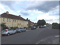
1
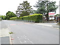
London Countryway in Kent (16)
The route passes Kings Farm School on Cedar Avenue.
Image: © Shazz
Taken: 10 Jul 2016
0.04 miles
2
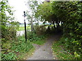
London Countryway in Kent (17)
An enclosed footpath is followed here.
Image: © Shazz
Taken: 10 Jul 2016
0.06 miles
3
London Countryway in Kent (15)
This is the pathway from Cedar Avenue between the school and playing fields.
Image: © Shazz
Taken: 10 Jul 2016
0.08 miles
4
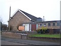
Holy Family Church, Singlewell
On Palmers Avenue, almost opposite Mungo Park Road.
Image: © David Anstiss
Taken: 31 Dec 2008
0.17 miles
5
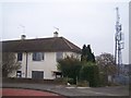
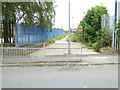
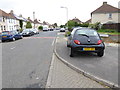
Mobile Phone Mast on Palmer Avenue
Houses on left are part of an Council estate of pre-war prefabs. These are now being knocked down and new, better houses are being built instead. This phone mast is on hill over most of Singlewell so serves a large area of people.
Image: © David Anstiss
Taken: 31 Dec 2008
0.20 miles
7
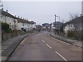
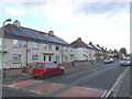
Palmers Avenue, Gravesend
These are part of an estate of pre-war pre-fab built council houses. The estate includes Palmers Avenue, Hawkins Avenue and Ferguson Avenue. This estate is now being knocked down and new, better homes are being built instead. The new homes are shown in photo at end of the road. Some of the old houses were bought from the Council ("maggie's" - buy your council house scheme). Even these are being bought back by the council so that the estate could fully be changed. The estate also had a bad reputation but now since most of the families have been relocated, it is hoped the estate will re-generate into a new community. Due to council budgets only a small section of the estate has been done, the rest of the estate is still waiting, but due to empty houses the area is now a target for vandalism and rubbish dumping.
Image: © David Anstiss
Taken: 31 Dec 2008
0.21 miles
8
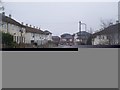
Palmers Avenue, Gravesend
These are part of an estate of pre-war pre-fab built council houses. The estate includes Palmers Avenue, Hawkins Avenue and Ferguson Avenue. This estate is now being knocked down and new, better homes are being built instead. The new homes are shown in photo at end of the road. Some of the old houses were bought from the Council ('buy your council house scheme'). Even these are being bought back by the council so that the estate could fully be changed. The estate also had a bad reputation but now since most of the families have been relocated, it is hoped the estate will re-generate into a new community. Due to council budgets only a small section of the estate has been done, the rest of the estate is still waiting, but due to empty houses the area is now a for vandalism and rubbish dumping.
Image: © David Anstiss
Taken: 31 Dec 2008
0.21 miles
10
London Countryway in Kent (14)
This is looking along Ash Road from the junction with Cedar Road.
Image: © Shazz
Taken: 10 Jul 2016
0.22 miles