IMAGES TAKEN NEAR TO
The Hollies, GRAVESEND, DA12 5ER
Introduction
This page details the photographs taken nearby to The Hollies, DA12 5ER by members of the Geograph project.
The Geograph project started in 2005 with the aim of publishing, organising and preserving representative images for every square kilometre of Great Britain, Ireland and the Isle of Man.

There are currently over 7.5m images from over14,400 individuals and you can help contribute to the project by visiting https://www.geograph.org.uk
Image Map
Images are licensed for reuse under creativecommons.org/licenses/by-sa/2.0
Notes
- Clicking on the map will re-center to the selected point.
- The higher the marker number, the further away the image location is from the centre of the postcode.
Image Listing (23 Images Found)
Images are licensed for reuse under creativecommons.org/licenses/by-sa/2.0
Image
Details
Distance
1
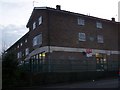
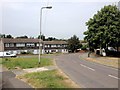
Singlewell Library
On junction of Ifield Way (in front) and Mackenzie Way (unseen to the left). Library at end of small parade of shops, with a small carpark on Mackenzie Way.
Image: © David Anstiss
Taken: 30 Jan 2009
0.15 miles
3
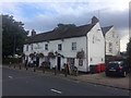
London Countryway in Kent (21)
The walk goes east along this stretch of tarmac which is free from motor vehicles. Two hotels are passed.
Image: © Shazz
Taken: 10 Jul 2016
0.16 miles
4
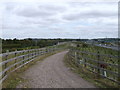
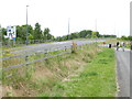
Track to Roman Road cyclepath
This footpath track leads from Image, down to the old (re-routed) A2, now a footpath and cycleway.
On the far-right is the dual-carriageway A2.
Image: © David Anstiss
Taken: 30 Sep 2012
0.16 miles
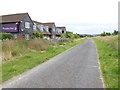
5
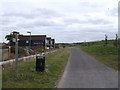
Footpath/cyclepath on the roman road
This footpath/cyclepath follows the route of the old Watling Street roman road.
It uses the tarmac of the old re-routed A2 dual carriageway. The rest of the road has been landscaped.
Image: © David Anstiss
Taken: 30 Sep 2012
0.16 miles
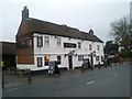
8
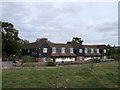
Premier Inn, Gravesend
This motel is beside Hever Road.
It was beside the A2 road. Where the trees are in the foreground. It is now beside a cyclepath/footpath on the old roman road.
Image: © David Anstiss
Taken: 30 Sep 2012
0.17 miles
9
London Countryway in Kent (22)
The Countryway approaches Hever Court Road again.
Image: © Shazz
Taken: 10 Jul 2016
0.19 miles
10
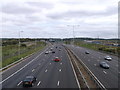
A2 (dual carriageway) to Medway
As seen from Image
This dual carriageway leads from London, under the M25 and then past Gravesend towards the Medway Towns and the M2 Motorway.
In the background the slip roads to Singlewell (on the left) and Cobham (to the right).
In 2009, this section of the A2 Watling Street was widened to 3/4 lanes (each side), it was also re-routed to make room for the new lanes.
The old road, since then has been converted into a cycle/footpath (just seen on the far-left).
Image: © David Anstiss
Taken: 30 Sep 2012
0.20 miles