IMAGES TAKEN NEAR TO
Crown Lane, GRAVESEND, DA12 3DY
Introduction
This page details the photographs taken nearby to Crown Lane, DA12 3DY by members of the Geograph project.
The Geograph project started in 2005 with the aim of publishing, organising and preserving representative images for every square kilometre of Great Britain, Ireland and the Isle of Man.

There are currently over 7.5m images from over14,400 individuals and you can help contribute to the project by visiting https://www.geograph.org.uk
Image Map
Images are licensed for reuse under creativecommons.org/licenses/by-sa/2.0
Notes
- Clicking on the map will re-center to the selected point.
- The higher the marker number, the further away the image location is from the centre of the postcode.
Image Listing (90 Images Found)
Images are licensed for reuse under creativecommons.org/licenses/by-sa/2.0
Image
Details
Distance
1
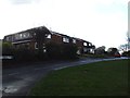
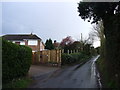
Crown Lane Shorne
This is the junction of Crown Lane and The Street in Shorne. The seat on the green was dedicated at the coronation of the Queen in 1953
Image: © Glyn Baker
Taken: 2 Apr 2006
0.02 miles
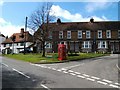
2
Shorne Village Sign
On Green at junction of Forge Lane, Crown Lane and The Street. Crown Lane is in background leading to A226 Gravesend Road. The Houses on left are on The Street heading into Shorne. The sign is metal painted black, with gold on name.
Image: © David Anstiss
Taken: 31 Dec 2008
0.03 miles
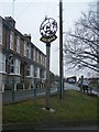
5
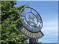
The village sign at Shorne
The village sign of Shorne includes the parish church of St Peter and St Paul, as well as features of the marshes like a dragonfly and reedmace.
Image: © Marathon
Taken: 13 Jul 2017
0.05 miles
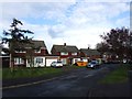
6
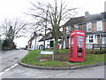
Junction of Crown Lane and The Street, Shorne
Image: © Chris Whippet
Taken: 27 Feb 2010
0.05 miles
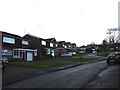
8
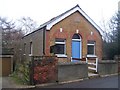
Shorne Methodist Church
On The Street. Has small hall hidden in dip behind the church, accessed on right of church.
OS Large Scale Map position of this church is incorrect, as it is on the East side of The Street. Explore 163 shows church in correct position.
Image: © David Anstiss
Taken: 31 Dec 2008
0.08 miles
9
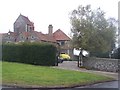
St Katherine's Court, Shorne
On junction of Forge Lane and Malthouse Lane.
St Katherine's Chapel, Roman Catholic Chapel is linked to this lovely building.
Red Roof on far left is the chapel building. The chapel is accessed by gap in hedge (unseen on left). Unknown, if linked to 'The Sons of Divine Providence', an American based Roman Catholic group which use the Chapel.
Image: © David Anstiss
Taken: 31 Dec 2008
0.09 miles