IMAGES TAKEN NEAR TO
Battle Street, GRAVESEND, DA12 3DB
Introduction
This page details the photographs taken nearby to Battle Street, DA12 3DB by members of the Geograph project.
The Geograph project started in 2005 with the aim of publishing, organising and preserving representative images for every square kilometre of Great Britain, Ireland and the Isle of Man.

There are currently over 7.5m images from over14,400 individuals and you can help contribute to the project by visiting https://www.geograph.org.uk
Image Map
Images are licensed for reuse under creativecommons.org/licenses/by-sa/2.0
Notes
- Clicking on the map will re-center to the selected point.
- The higher the marker number, the further away the image location is from the centre of the postcode.
Image Listing (170 Images Found)
Images are licensed for reuse under creativecommons.org/licenses/by-sa/2.0
Image
Details
Distance
4
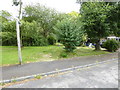
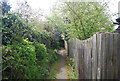
London Countryway in Kent (35)
A footpath is taken here from Sarsens Close.
Image: © Shazz
Taken: 10 Jul 2016
0.04 miles
6
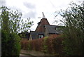
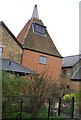
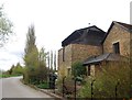
Mulberry Oast, Battle Street, Cobham, Kent
Image: © Oast House Archive
Taken: 29 May 2008
0.05 miles
8
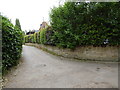
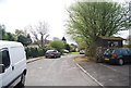
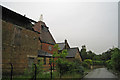
London Countryway in Kent (34)
At this junction the Countryway turns right onto Battle Road.
Image: © Shazz
Taken: 10 Jul 2016
0.05 miles