IMAGES TAKEN NEAR TO
Carrington Road, DARTFORD, DA1 1XW
Introduction
This page details the photographs taken nearby to Carrington Road, DA1 1XW by members of the Geograph project.
The Geograph project started in 2005 with the aim of publishing, organising and preserving representative images for every square kilometre of Great Britain, Ireland and the Isle of Man.

There are currently over 7.5m images from over14,400 individuals and you can help contribute to the project by visiting https://www.geograph.org.uk
Image Map
Images are licensed for reuse under creativecommons.org/licenses/by-sa/2.0
Notes
- Clicking on the map will re-center to the selected point.
- The higher the marker number, the further away the image location is from the centre of the postcode.
Image Listing (59 Images Found)
Images are licensed for reuse under creativecommons.org/licenses/by-sa/2.0
Image
Details
Distance

4
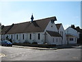
St Alban's Church
On junction of St Alban's road (in front), and Colney Road (on left).
Image: © David Anstiss
Taken: 29 Apr 2009
0.11 miles
5
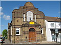
The Vietnamese Buddhist Meditation Centre
Converted church on junction of St Albans Road (in front) and Colney Road (on left). It is part of the Medicine Buddha Foundation UK. It has an engraved foundation stone which reads 'To the Glory of God. This stone was laid by Florence Edith Miskin Sept 13th 1911 F.W. Hassard Short - Vicar.'
Image: © David Anstiss
Taken: 29 Apr 2009
0.11 miles
6
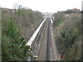
Dartford: Railway line from the St Vincents Road bridge (1)
The railway between Dartford and Stone runs in a very deep cutting here where St Vincents Road crosses the line. The sidings hold trains stabled during non-peak hour times. See Image for the view in the opposite direction.
Image: © Nigel Cox
Taken: 2 Mar 2008
0.11 miles
7
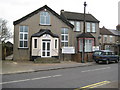
Dartford: The Redeemed Christian Church of God
The Redeemed Christian Church of God was established in Nigeria in 1952 http://rccg.org/./index.rccg This place of worship is in St Vincents Road, opposite Image
Image: © Nigel Cox
Taken: 2 Mar 2008
0.12 miles
8
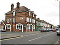
Dartford: The Fulwich Hotel
The Fulwich is an Edwardian era public house that offers B & B, located on St Vincents Road at its junction with Carlisle Road. It still has an old Taylor Walker Brewery sign outside. Taylor Walker owned the Barley Mow Brewery in Limehouse from 1816 until 1959 when they were taken over by Ind Coope, and the brewery was closed in 1960.
Image: © Nigel Cox
Taken: 2 Mar 2008
0.12 miles