IMAGES TAKEN NEAR TO
Holly Court, High Street, GRAVESEND, DA11 9HX
Introduction
This page details the photographs taken nearby to Holly Court, High Street, DA11 9HX by members of the Geograph project.
The Geograph project started in 2005 with the aim of publishing, organising and preserving representative images for every square kilometre of Great Britain, Ireland and the Isle of Man.

There are currently over 7.5m images from over14,400 individuals and you can help contribute to the project by visiting https://www.geograph.org.uk
Image Map
Images are licensed for reuse under creativecommons.org/licenses/by-sa/2.0
Notes
- Clicking on the map will re-center to the selected point.
- The higher the marker number, the further away the image location is from the centre of the postcode.
Image Listing (62 Images Found)
Images are licensed for reuse under creativecommons.org/licenses/by-sa/2.0
Image
Details
Distance
5
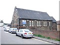
The Redeemed Christian Church of God, City of his Grace, Northfleet
Image: © Chris Whippet
Taken: 22 Sep 2013
0.06 miles
7
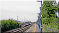
Northfleet station, 2005
View NW, towards Dartford and London: ex-SE&CR North Kent line, Charing Cross/Cannon Street - Greenwich - Dartford - Gravesend - Strood.
Image: © Ben Brooksbank
Taken: 7 Sep 2005
0.07 miles
8
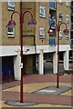
External paved area, The Hive, Northfleet
Image: © David Martin
Taken: 22 Jul 2018
0.07 miles
9
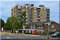
Mixed residential and commercial use at The Hive, Northfleet
Image: © David Martin
Taken: 22 Jul 2018
0.07 miles