IMAGES TAKEN NEAR TO
Vicarage Drive, GRAVESEND, DA11 9HA
Introduction
This page details the photographs taken nearby to Vicarage Drive, DA11 9HA by members of the Geograph project.
The Geograph project started in 2005 with the aim of publishing, organising and preserving representative images for every square kilometre of Great Britain, Ireland and the Isle of Man.

There are currently over 7.5m images from over14,400 individuals and you can help contribute to the project by visiting https://www.geograph.org.uk
Image Map
Images are licensed for reuse under creativecommons.org/licenses/by-sa/2.0
Notes
- Clicking on the map will re-center to the selected point.
- The higher the marker number, the further away the image location is from the centre of the postcode.
Image Listing (77 Images Found)
Images are licensed for reuse under creativecommons.org/licenses/by-sa/2.0
Image
Details
Distance
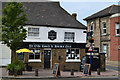
3
The Queen's Head, Northfleet, viewed from the churchyard of St. Botolph's
Viewed from the south east corner of the church and towards the lychgate.
Image: © pam fray
Taken: 20 Jul 2009
0.04 miles
4
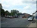
Ye Olde Coach and Horses Inn, Northfleet
Image: © David Martin
Taken: 22 Jul 2018
0.05 miles
7
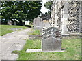
Path leading through the churchyard of St. Botolph's, Northfleet
The path leads from The Hill, Northfleet along the south side of the church.
Image: © pam fray
Taken: 20 Jul 2009
0.05 miles
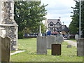
8
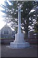
Northfleet War Memorial
Near St.Boloph's Church on the Hill.
Image: © David Anstiss
Taken: 23 Oct 2009
0.05 miles
10
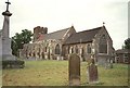
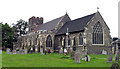
St Botolph, Northfleet, Kent - East end
Image: © John Salmon
Taken: 21 Sep 2005
0.06 miles