IMAGES TAKEN NEAR TO
Crete Hall Road, DA11 9GL
Introduction
This page details the photographs taken nearby to Crete Hall Road, DA11 9GL by members of the Geograph project.
The Geograph project started in 2005 with the aim of publishing, organising and preserving representative images for every square kilometre of Great Britain, Ireland and the Isle of Man.

There are currently over 7.5m images from over14,400 individuals and you can help contribute to the project by visiting https://www.geograph.org.uk
Image Map
Images are licensed for reuse under creativecommons.org/licenses/by-sa/2.0
Notes
- Clicking on the map will re-center to the selected point.
- The higher the marker number, the further away the image location is from the centre of the postcode.
Image Listing (90 Images Found)
Images are licensed for reuse under creativecommons.org/licenses/by-sa/2.0
Image
Details
Distance
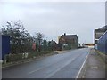
4
Crete Hall Road, Northfleet
On the left is the former W T Henley AEI Cable Works.
Image: © Chris Whippet
Taken: 23 Aug 2014
0.02 miles
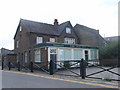
5
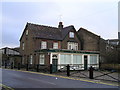
The Old Sun Pub, Gravesend
Crete Hall Road, Gravesend, DA11 9AA on the River Thames Tideway
Image: © canalandriversidepubs co uk
Taken: 7 Feb 2010
0.02 miles
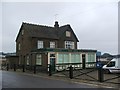
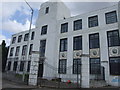
6
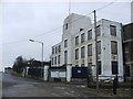
W T Henley/ AEI office building, Northfleet
Now disused offices of the cable works that used to be here.
Image: © Chris Whippet
Taken: 1 Jan 2015
0.03 miles
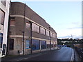
7
W.T. Henley's cable works, Northfleet
Image: © Chris Whippet
Taken: 16 Jul 2010
0.03 miles
9
River Thames, The Henley Building at Northfleet
Disused art-deco style office building.
Image: © David Dixon
Taken: 28 Oct 2018
0.03 miles
10
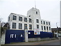
The former offices of W T Henley?s Cable Works at Rosherville
No part of Gravesend is more run down at present than the area along by the river to the west of the centre, in the area known as Rosherville. Rosherville Gardens were laid out in 1837 in one of the disused chalk pits next to Crete Hall Road, and covered an area of 17 acres. Their full title was the 'Kent Zoological and Botanical Gardens Institution’. In the Victorian period they became a favourite destination for thousands of Londoners, many travelling by paddle steamer down the River Thames to disembark at the pier built to service the gardens. In the 1850s up to 20,000 visitors passed through the turnstiles in a week. By 1880 the gardens had reached the peak of their popularity and in 1901 they were closed.
In 1924 five acres of the land was sold to W T Henley’s Cable Works, which had occupied the land between Rosherville Gardens and the Thames since 1906. In 1939 Henley’s bought the rest of the land and the site was completely cleared. Most of Henley's Works has in turn been cleared, but the former offices built in the 1930s in art deco style remain as seen here on the corner of The Shore and Crete Hall Road. Henley's ship emblem can be seen below each of the first floor windows. The area will soon be redeveloped again as part of the Thames Gateway but hopefully this building can be saved and put to use again.
Image: © Marathon
Taken: 5 Apr 2012
0.03 miles