IMAGES TAKEN NEAR TO
Durndale Lane, GRAVESEND, DA11 8PF
Introduction
This page details the photographs taken nearby to Durndale Lane, DA11 8PF by members of the Geograph project.
The Geograph project started in 2005 with the aim of publishing, organising and preserving representative images for every square kilometre of Great Britain, Ireland and the Isle of Man.

There are currently over 7.5m images from over14,400 individuals and you can help contribute to the project by visiting https://www.geograph.org.uk
Image Map
Images are licensed for reuse under creativecommons.org/licenses/by-sa/2.0
Notes
- Clicking on the map will re-center to the selected point.
- The higher the marker number, the further away the image location is from the centre of the postcode.
Image Listing (11 Images Found)
Images are licensed for reuse under creativecommons.org/licenses/by-sa/2.0
Image
Details
Distance
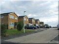
1
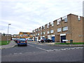
Cyclo-circuit, Cyclopark
This smooth, tarmac circuit is 2.9 kilometres long and 6 metres wide, used for cycling races, coaching sessions, training rides and general fitness cycling as well as skating and running.
The circuit can be separated into a number of smaller circuits so everybody can perfect their skills. Also used for inline skating, competitive wheelchair racing and slalom skateboarding.
Image: © David Anstiss
Taken: 30 Sep 2012
0.16 miles
3
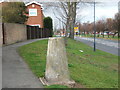
Triangulation Pillar, In Boucher Dr, Gravesend
When first made there would have been fantastic views from this triangulation point now they are blocked by houses.
Image: © Glyn Baker
Taken: 1 Apr 2006
0.20 miles
6
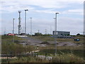
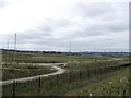
BMX Racetrack, Cyclopark
One of the parts of the large cyclepark, built on the fields beside the site of the old re-routed A2 road.
In the background is Image
Image: © David Anstiss
Taken: 30 Sep 2012
0.22 miles
7
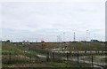
Cyclopark Playground
Also includes Outdoor Gym and Sensory Garden.
Image: © David Anstiss
Taken: 30 Sep 2012
0.23 miles
8
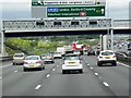
Sign gantry on A2
Between camera and road runs the Channel Tunnel Rail Link in a cutting.
Image: © Robin Webster
Taken: 25 Sep 2011
0.23 miles
9
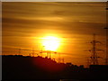
A brilliantly orange sunset on the A2
The evening of the 3rd May was marked by this brilliantly orange sunset, which we had the pleasure of travelling through on the way home from Birchington on Thanet. This is the probably the only spot where you can really picture sunsets in all their glory because of the very open countryside at this point. The plethora of pylons and the hills in the distance also give an interesting silhouette effect. This view was taken looking west-northwest from the London-bound carriageway of the new A2 (constructed in 2008).
Image: © Robert Lamb
Taken: 3 May 2009
0.23 miles
10
Sign gantry and Footbridge over Watling Street
Image: © David Dixon
Taken: 15 May 2013
0.24 miles