IMAGES TAKEN NEAR TO
Grangeways Close, GRAVESEND, DA11 8NX
Introduction
This page details the photographs taken nearby to Grangeways Close, DA11 8NX by members of the Geograph project.
The Geograph project started in 2005 with the aim of publishing, organising and preserving representative images for every square kilometre of Great Britain, Ireland and the Isle of Man.

There are currently over 7.5m images from over14,400 individuals and you can help contribute to the project by visiting https://www.geograph.org.uk
Image Map
Images are licensed for reuse under creativecommons.org/licenses/by-sa/2.0
Notes
- Clicking on the map will re-center to the selected point.
- The higher the marker number, the further away the image location is from the centre of the postcode.
Image Listing (17 Images Found)
Images are licensed for reuse under creativecommons.org/licenses/by-sa/2.0
Image
Details
Distance
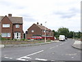
1
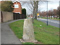
Triangulation Pillar, In Boucher Dr, Gravesend
When first made there would have been fantastic views from this triangulation point now they are blocked by houses.
Image: © Glyn Baker
Taken: 1 Apr 2006
0.04 miles
4
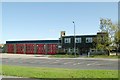
Thames-Side fire station
Thames-Side fire station, Coldharbour Road, Northfleet, Gravesend, Kent
Image: © Kevin Hale
Taken: 17 Oct 2007
0.15 miles
6
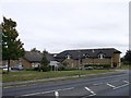
Eleanor Lions Hospice, Gravesend
Care home beside Coldharbour Road.
Image: © David Anstiss
Taken: 30 Sep 2012
0.17 miles
7
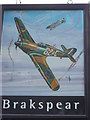
Battle of Britain Pub Sign (2)
Image: © David Anstiss
Taken: 30 Sep 2012
0.19 miles
8
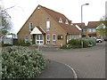
Clements Close Catholic Church
On Coldharbour Road.
Image: © David Anstiss
Taken: 9 Apr 2009
0.19 miles
9
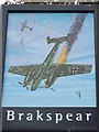
Battle of Britain Pub Sign, Gravesend
Image: © David Anstiss
Taken: 30 Sep 2012
0.19 miles
10
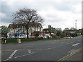
Battle of Britain Public House, Northfleet
On the junction of Coldharbour Road (in front) and New House Lane (on left).
Image: © David Anstiss
Taken: 9 Apr 2009
0.20 miles