IMAGES TAKEN NEAR TO
Foxberry Walk, GRAVESEND, DA11 8ND
Introduction
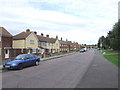
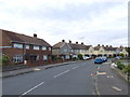
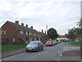
This page details the photographs taken nearby to Foxberry Walk, DA11 8ND by members of the Geograph project.
The Geograph project started in 2005 with the aim of publishing, organising and preserving representative images for every square kilometre of Great Britain, Ireland and the Isle of Man.

There are currently over 7.5m images from over14,400 individuals and you can help contribute to the project by visiting https://www.geograph.org.uk
Image Map
Images are licensed for reuse under creativecommons.org/licenses/by-sa/2.0
Notes
- Clicking on the map will re-center to the selected point.
- The higher the marker number, the further away the image location is from the centre of the postcode.
Image Listing (27 Images Found)
Images are licensed for reuse under creativecommons.org/licenses/by-sa/2.0
Image
Details
Distance
8
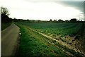
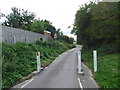
Hog Lane (prior to redevelopment for CTRL)
The landscape has been completely changed with:
a: Channel Tunnel Rail Link (CTRL)
b: Re-routing of A2 at Gravesend
Image: © Roger Smith
Taken: 19 Dec 1994
0.14 miles