IMAGES TAKEN NEAR TO
Waterdales, GRAVESEND, DA11 8JW
Introduction
This page details the photographs taken nearby to Waterdales, DA11 8JW by members of the Geograph project.
The Geograph project started in 2005 with the aim of publishing, organising and preserving representative images for every square kilometre of Great Britain, Ireland and the Isle of Man.

There are currently over 7.5m images from over14,400 individuals and you can help contribute to the project by visiting https://www.geograph.org.uk
Image Map
Images are licensed for reuse under creativecommons.org/licenses/by-sa/2.0
Notes
- Clicking on the map will re-center to the selected point.
- The higher the marker number, the further away the image location is from the centre of the postcode.
Image Listing (20 Images Found)
Images are licensed for reuse under creativecommons.org/licenses/by-sa/2.0
Image
Details
Distance
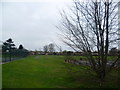
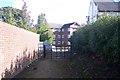
1
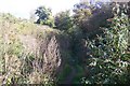
Footpath on dismantled railway
An old line ran from Gravesend to Southfleet. A footpath now uses the route from Springhead Road to a recreational ground near Waterdales.
Image: © David Anstiss
Taken: 23 Oct 2009
0.06 miles
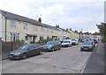
7
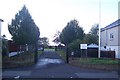
Entrance to Wombwell Park
On Mitchell Avenue. A square recreational ground.
Image: © David Anstiss
Taken: 23 Oct 2009
0.14 miles
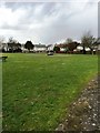
8
Wombwell Park, Northfleet
This is not the easiest of parks to get a good photograph and on a day like this even less so.
Image: © Marathon
Taken: 5 Apr 2012
0.14 miles
9
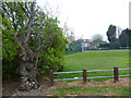
Old tree at entrance to Wombwell Park
Just inside the entrance to Wombwell Park from Mitchell Avenue, this gnarled tree may well be the oldest thing in the park.
Image: © Marathon
Taken: 5 Apr 2012
0.15 miles
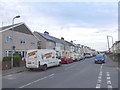
10
Footpath near Springhead Park
A footpath from Hall Road leads around the back of the Sainsbury Supermarket, then leads past a large housing estate,(Springhead Park, and brick wall) then leads to Springhead Road. Note, footpaths do not match OS Map due to new estate boundaries.
Image: © David Anstiss
Taken: 23 Oct 2009
0.17 miles