IMAGES TAKEN NEAR TO
Springhead Parkway, GRAVESEND, DA11 8JJ
Introduction
This page details the photographs taken nearby to Springhead Parkway, DA11 8JJ by members of the Geograph project.
The Geograph project started in 2005 with the aim of publishing, organising and preserving representative images for every square kilometre of Great Britain, Ireland and the Isle of Man.

There are currently over 7.5m images from over14,400 individuals and you can help contribute to the project by visiting https://www.geograph.org.uk
Image Map
Images are licensed for reuse under creativecommons.org/licenses/by-sa/2.0
Notes
- Clicking on the map will re-center to the selected point.
- The higher the marker number, the further away the image location is from the centre of the postcode.
Image Listing (10 Images Found)
Images are licensed for reuse under creativecommons.org/licenses/by-sa/2.0
Image
Details
Distance
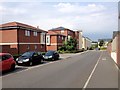
1
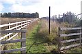
Footpath to Springhead Road
This path leads from a path running alongside the Channel Tunnel Rail Link near Ebbsfleet Station. The path leads past Springhead Park Construction Site boundary fence (on the right), then later past Springhead Enterprise Park (on the left, beyond the trees in the background). Footpaths do not match OS Maps due to the construction site and the rail link.
Image: © David Anstiss
Taken: 23 Oct 2009
0.06 miles
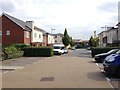
2
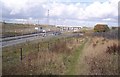
Footpath beside the Channel Tunnel Railway Link
This path leads from the b259 Watling Street towards Ebbsfleet Station. In the background is a road bridge over the CTRL, leading left towards the A2 from Northfleet.
Image: © David Anstiss
Taken: 23 Oct 2009
0.06 miles
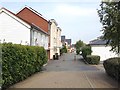
3
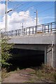
CTRL bridge over footpath
The Channel Tunnel Rail Link (heading towards Ebbsfleet Station) leads over a footpath beside a drainage stream leading from the B259 Watling Street towards Thames Way.
Image: © David Anstiss
Taken: 23 Oct 2009
0.10 miles
4
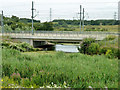
The CTRL crosses Ebbsfleet
Only when researching the name of this waterway did I find out that the station was named after it. The station is some way to the right - the tracks have already started to fan out here.
Image: © Robin Webster
Taken: 12 Jul 2011
0.12 miles
8

Footbridge near Northfleet Sewage Works
This bridge is over a stream leading from alongside the Channel Tunnel Rail Link to a disused quarry (now a lake). The bridge is on a path from the B259 Watling Street leading to Thames Way.
Image: © David Anstiss
Taken: 23 Oct 2009
0.21 miles
9
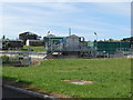
Northfleet Wastewater Treatment Works
Image: © Danny P Robinson
Taken: 24 Aug 2014
0.22 miles