IMAGES TAKEN NEAR TO
Trosley Avenue, GRAVESEND, DA11 7QN
Introduction
This page details the photographs taken nearby to Trosley Avenue, DA11 7QN by members of the Geograph project.
The Geograph project started in 2005 with the aim of publishing, organising and preserving representative images for every square kilometre of Great Britain, Ireland and the Isle of Man.

There are currently over 7.5m images from over14,400 individuals and you can help contribute to the project by visiting https://www.geograph.org.uk
Image Map
Images are licensed for reuse under creativecommons.org/licenses/by-sa/2.0
Notes
- Clicking on the map will re-center to the selected point.
- The higher the marker number, the further away the image location is from the centre of the postcode.
Image Listing (59 Images Found)
Images are licensed for reuse under creativecommons.org/licenses/by-sa/2.0
Image
Details
Distance
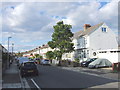
1
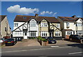
Wrotham Road (A227), Gravesend
Looking south.
Image: © JThomas
Taken: 20 Jun 2022
0.04 miles
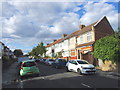
4
Woodland Park gates
Entrance of Wrotham Road.
Image: © JThomas
Taken: 21 Jun 2022
0.05 miles
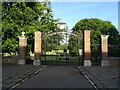
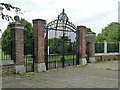
6

Entrance Gate to Woodlands Park
On Wrotham Road. Lovely crafted iron gates. Park large open recreation area.
Image: © David Anstiss
Taken: 31 Dec 2008
0.06 miles
7
Gates, Woodlands Park, Gravesend
In memory of George V.
Image: © Robin Webster
Taken: 27 Jun 2011
0.06 miles