IMAGES TAKEN NEAR TO
Elizabeth Huggins Court, DA11 7LX
Introduction
This page details the photographs taken nearby to Elizabeth Huggins Court, DA11 7LX by members of the Geograph project.
The Geograph project started in 2005 with the aim of publishing, organising and preserving representative images for every square kilometre of Great Britain, Ireland and the Isle of Man.

There are currently over 7.5m images from over14,400 individuals and you can help contribute to the project by visiting https://www.geograph.org.uk
Image Map
Images are licensed for reuse under creativecommons.org/licenses/by-sa/2.0
Notes
- Clicking on the map will re-center to the selected point.
- The higher the marker number, the further away the image location is from the centre of the postcode.
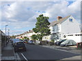
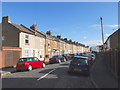
Image Listing (46 Images Found)
Images are licensed for reuse under creativecommons.org/licenses/by-sa/2.0
Image
Details
Distance
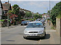
5
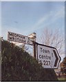
Old Direction Sign - Signpost by the A227, Wrotham Road
No finial - 3 arms, 1 Worboys; Kent CC by the A227, in parish of Gravesend (Gravesham District), Wrotham Road junction with New House Lane.
Surveyed
Milestone Society National ID: KE_TQ6472
Image: © Milestone Society
Taken: Unknown
0.05 miles
8
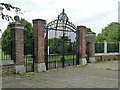
Gates, Woodlands Park, Gravesend
In memory of George V.
Image: © Robin Webster
Taken: 27 Jun 2011
0.08 miles
10
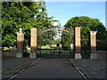
Woodland Park gates
Entrance of Wrotham Road.
Image: © JThomas
Taken: 21 Jun 2022
0.09 miles