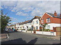
IMAGES TAKEN NEAR TO
Cecil Road, GRAVESEND, DA11 7DG
Introduction
This page details the photographs taken nearby to Cecil Road, DA11 7DG by members of the Geograph project.
The Geograph project started in 2005 with the aim of publishing, organising and preserving representative images for every square kilometre of Great Britain, Ireland and the Isle of Man.

There are currently over 7.5m images from over14,400 individuals and you can help contribute to the project by visiting https://www.geograph.org.uk
Image Map
Images are licensed for reuse under creativecommons.org/licenses/by-sa/2.0
Notes
- Clicking on the map will re-center to the selected point.
- The higher the marker number, the further away the image location is from the centre of the postcode.
Image Listing (57 Images Found)
Images are licensed for reuse under creativecommons.org/licenses/by-sa/2.0
Image
Details
Distance
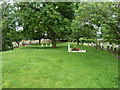
1
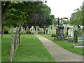
Path in Gravesend Cemetery
This old part of the cemetery is a grade II*(star) listed 'park or garden'. It was opened in the 1830s as a paying pleasure gardens but rather quickly converted into a more profitable cemetery.
Image: © Robin Webster
Taken: 27 Jun 2011
0.02 miles
3
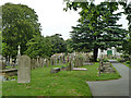
In Gravesend Cemetery
This old part of the cemetery is a grade II*(star) listed 'park or garden'. It was opened in the 1830s as a paying pleasure gardens but rather quickly converted into a more profitable cemetery.
Image: © Robin Webster
Taken: 27 Jun 2011
0.04 miles
4
In Gravesend Cemetery
The western end of the catacombs, which were never completed as they fell out of fashion. This old part of the cemetery is a grade II*(star) listed 'park or garden'. It was opened in the 1830s as a paying pleasure gardens but rather quickly converted into a more profitable cemetery.
Image: © Robin Webster
Taken: 27 Jun 2011
0.04 miles
5
Roof of western catacombs, Gravesend Cemetery
This old part of the cemetery is a grade II*(star) listed 'park or garden'. It was opened in the 1830s as a paying pleasure gardens but rather quickly converted into a more profitable cemetery. These catacombs, which the architect was keen on but the public weren't, were not a financial success, and were never completed. The view is taken from the top of the eastern part, which was demolished and remains as a raised bank.
Image: © Robin Webster
Taken: 27 Jun 2011
0.06 miles
6
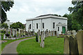
Mortuary Chapel, Gravesend Cemetery
A grade II listed building, about 1838. This old section of the cemetery is a grade II*(star) listed 'park or garden'. It was opened in the 1830s as a paying pleasure gardens but rather quickly converted into a more profitable cemetery.
Image: © Robin Webster
Taken: 27 Jun 2011
0.06 miles
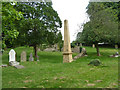
7
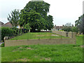
Site of catacombs, Gravesend Cemetery
The bank had, or was to have, the catacomb wall to the left, curving round to the brown obelisk just visible through the trees, a mirrored version of the surviving western part, see Image These catacombs, which the architect was keen on but the public weren't, were not a financial success, and were never completed. Whatever was here of this eastern part was demolished some time later. This old section of the cemetery is a grade II*(star) listed 'park or garden'. It was opened in the 1830s as a paying pleasure gardens but rather quickly converted into a more profitable cemetery.
Image: © Robin Webster
Taken: 27 Jun 2011
0.08 miles
10
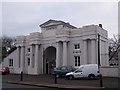
Grand Entrance to Gravesend Cemetery
On Old Road West.
Image: © David Anstiss
Taken: 18 Dec 2008
0.09 miles