IMAGES TAKEN NEAR TO
Coopers Road, GRAVESEND, DA11 7BA
Introduction
This page details the photographs taken nearby to Coopers Road, DA11 7BA by members of the Geograph project.
The Geograph project started in 2005 with the aim of publishing, organising and preserving representative images for every square kilometre of Great Britain, Ireland and the Isle of Man.

There are currently over 7.5m images from over14,400 individuals and you can help contribute to the project by visiting https://www.geograph.org.uk
Image Map
Images are licensed for reuse under creativecommons.org/licenses/by-sa/2.0
Notes
- Clicking on the map will re-center to the selected point.
- The higher the marker number, the further away the image location is from the centre of the postcode.
Image Listing (75 Images Found)
Images are licensed for reuse under creativecommons.org/licenses/by-sa/2.0
Image
Details
Distance
1
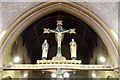
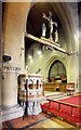
All Saints, Perry Street, Northfleet, Kent - Rood
Image: © John Salmon
Taken: 21 Jul 2009
0.04 miles
2
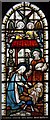
All Saints, Perry Street, Northfleet, Kent - Window
Image: © John Salmon
Taken: 21 Jul 2009
0.04 miles
3
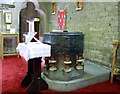
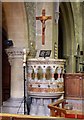
All Saints, Perry Street, Northfleet, Kent - Font
Image: © John Salmon
Taken: 21 Jul 2009
0.04 miles
4
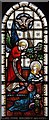
All Saints, Perry Street, Northfleet, Kent - Window
Image: © John Salmon
Taken: 21 Jul 2009
0.04 miles
5
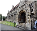
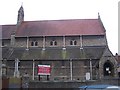
All Saints, Perry Street, Northfleet, Kent
Image: © John Salmon
Taken: 21 Jul 2009
0.05 miles
7
All Saints, Perry Street, Northfleet, Kent - Pulpit & rood
Image: © John Salmon
Taken: 21 Jul 2009
0.05 miles
8
All Saints, Perry Street, Northfleet, Kent - Pulpit
Image: © John Salmon
Taken: 21 Jul 2009
0.05 miles
9
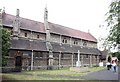
All Saints Church, Northfleet
On Perry Street. In the diocese of Rochester.
Image: © David Anstiss
Taken: 18 Dec 2008
0.05 miles
10
All Saints, Perry Street, Northfleet, Kent
Image: © John Salmon
Taken: 21 Jul 2009
0.05 miles