IMAGES TAKEN NEAR TO
Earl Road, GRAVESEND, DA11 7AF
Introduction
This page details the photographs taken nearby to Earl Road, DA11 7AF by members of the Geograph project.
The Geograph project started in 2005 with the aim of publishing, organising and preserving representative images for every square kilometre of Great Britain, Ireland and the Isle of Man.

There are currently over 7.5m images from over14,400 individuals and you can help contribute to the project by visiting https://www.geograph.org.uk
Image Map
Images are licensed for reuse under creativecommons.org/licenses/by-sa/2.0
Notes
- Clicking on the map will re-center to the selected point.
- The higher the marker number, the further away the image location is from the centre of the postcode.
Image Listing (64 Images Found)
Images are licensed for reuse under creativecommons.org/licenses/by-sa/2.0
Image
Details
Distance
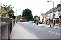
1
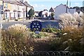
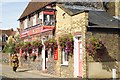
Rotary Club Golden Jubilee Garden
This small triangular garden is at the junction of Earl Road (on right) and Vale Road (on the left). Seen from a path near a pharmacy on the junction.
In the background is Perry Road and All Saint's Church.
Image: © David Anstiss
Taken: 23 Oct 2009
0.03 miles
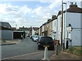
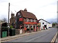
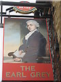
9
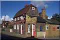
The Earl Grey Public House, Northfleet
On Vale Road, near junction with Earl Road.
Has flint covered walls.
Image: © David Anstiss
Taken: 23 Oct 2009
0.06 miles