IMAGES TAKEN NEAR TO
Darnley Road, GRAVESEND, DA11 0RX
Introduction
This page details the photographs taken nearby to Darnley Road, DA11 0RX by members of the Geograph project.
The Geograph project started in 2005 with the aim of publishing, organising and preserving representative images for every square kilometre of Great Britain, Ireland and the Isle of Man.

There are currently over 7.5m images from over14,400 individuals and you can help contribute to the project by visiting https://www.geograph.org.uk
Image Map
Images are licensed for reuse under creativecommons.org/licenses/by-sa/2.0
Notes
- Clicking on the map will re-center to the selected point.
- The higher the marker number, the further away the image location is from the centre of the postcode.
Image Listing (211 Images Found)
Images are licensed for reuse under creativecommons.org/licenses/by-sa/2.0
Image
Details
Distance
1
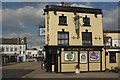
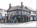
Somerset Arms, Gravesend
Pub at the junction of Darnley Road and Clive Road.
Image: © Stephen McKay
Taken: 19 Mar 2012
0.02 miles
3
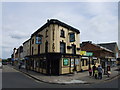
The Somerset Arms, Gravesend
On junction of 10 Darnley Road and Barrack Row.
Image: © David Anstiss
Taken: 18 Dec 2008
0.04 miles
5
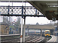
Gravesend station before remodelling
The train in the photo arriving from London consists of a pair of "Networker" units, 465003 leading, in different liveries ("South Central" and the older "Network Southeast").
In recent years, the station lost the through lines seen here in order to gain an extra platform for stopping trains Image
Image: © Stephen Craven
Taken: 15 Apr 2006
0.04 miles
6
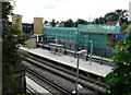
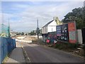
Ongoing construction at Gravesend Railway Station
Seen from Darnley Road, the ongoing construction relates to Gravesham Borough Council’s planning application 20151023, an “application for listed building consent for the erection of cycle hub building and ancillary cycle shop”.
Image: © John Baker
Taken: 21 Jul 2016
0.04 miles
7
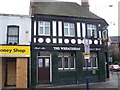
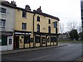
The Wheatsheaf Pub, Gravesend
On junction of 62 New Road (pedestrianised section) and Darnley Road.
The Money Shop beside has closed down, showing that even pawnbrokers are having a bad time in Gravesend.
Image: © David Anstiss
Taken: 18 Dec 2008
0.05 miles
9
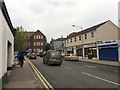
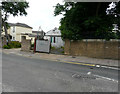
Rathmore Road, Gravesend
This area is undergoing extensive redevelopment to allow for improved access to Gravesend Railway Station.
Image: © Chris Whippet
Taken: 11 Aug 2016
0.05 miles
10
T H Waters, Darnley Road
The business specialized in house clearance. The condition of the building seems to indicate that it is no longer trading.
Image: © John Baker
Taken: 21 Jul 2016
0.05 miles