IMAGES TAKEN NEAR TO
Overcliffe, GRAVESEND, DA11 0EW
Introduction
This page details the photographs taken nearby to Overcliffe, DA11 0EW by members of the Geograph project.
The Geograph project started in 2005 with the aim of publishing, organising and preserving representative images for every square kilometre of Great Britain, Ireland and the Isle of Man.

There are currently over 7.5m images from over14,400 individuals and you can help contribute to the project by visiting https://www.geograph.org.uk
Image Map
Images are licensed for reuse under creativecommons.org/licenses/by-sa/2.0
Notes
- Clicking on the map will re-center to the selected point.
- The higher the marker number, the further away the image location is from the centre of the postcode.
Image Listing (82 Images Found)
Images are licensed for reuse under creativecommons.org/licenses/by-sa/2.0
Image
Details
Distance

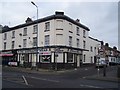
4
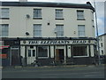
The Elephants Head, Northfleet
On London Road.
Image: © JThomas
Taken: 20 Jun 2022
0.04 miles
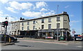
5
The Elephant's Head Pub, Gravesend
On junction of 106 London Road and Pier Road.
Image: © David Anstiss
Taken: 18 Dec 2008
0.04 miles
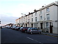
9
Burch Road, Gravesend
Burch Road in Gravesend, looking northwards to the River Thames.
Image: © Malc McDonald
Taken: 7 Sep 2013
0.11 miles
10
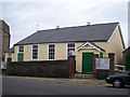
Full Gospel Church, Gravesend
On Pier Road. A corrugated iron sheet shed/building.
Image: © David Anstiss
Taken: 18 Dec 2008
0.12 miles