IMAGES TAKEN NEAR TO
Lennox Road, GRAVESEND, DA11 0EL
Introduction
This page details the photographs taken nearby to Lennox Road, DA11 0EL by members of the Geograph project.
The Geograph project started in 2005 with the aim of publishing, organising and preserving representative images for every square kilometre of Great Britain, Ireland and the Isle of Man.

There are currently over 7.5m images from over14,400 individuals and you can help contribute to the project by visiting https://www.geograph.org.uk
Image Map
Images are licensed for reuse under creativecommons.org/licenses/by-sa/2.0
Notes
- Clicking on the map will re-center to the selected point.
- The higher the marker number, the further away the image location is from the centre of the postcode.
Image Listing (41 Images Found)
Images are licensed for reuse under creativecommons.org/licenses/by-sa/2.0
Image
Details
Distance
3
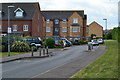
Beaumont Drive over A2260 Thames Way
Drive leads from Beaumont Road estate, to Rosherville/A226 London Road.
Red lanes on Thames Way are individual bus lanes, heading left to Northfleet from Gravesend.
Image: © David Anstiss
Taken: 18 Dec 2008
0.08 miles
6
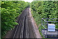
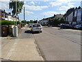
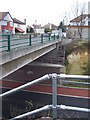
Looking down on the railway from Lennox Road
Image: © David Martin
Taken: 25 May 2019
0.11 miles